
Topografische kaart Newark
Interactieve kaart
Klik op de kaart om de hoogte weer te geven.
Over deze kaart
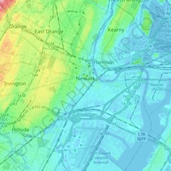
Naam: Topografische kaart Newark, hoogte, reliëf.
Locatie: Newark, Essex County, New Jersey, United States (40.67325 -74.25133 40.78814 -74.11418)
Gemiddelde hoogte: 22 m
Minimale hoogte: -11 m
Maximale hoogte: 131 m
According to the United States Census Bureau, the city had a total area of 25.89 square miles (67.1 km2), including 24.14 square miles (62.5 km2) of land and 1.74 square miles (4.5 km2) of water (6.72%). It has the third-smallest land area among the 100 most populous cities in the U.S., behind neighboring Jersey City and Hialeah, Florida. The city's altitude ranges from 0 (sea level) in the east to approximately 230 feet (70 m) above sea level in the western section of the city. Newark is essentially a large basin sloping towards the Passaic River, with a few valleys formed by meandering streams. Historically, Newark's high places have been its wealthier neighborhoods. In the 19th century and early 20th century, the wealthy congregated on the ridges of Forest Hill, High Street, and Weequahic.
Andere topografische kaarten
Klik op een kaart om zijn topografie, zijn hoogte en zijn reliëf te bekijken.
Millburn
United States > New Jersey > Essex County
Millburn, Essex County, New Jersey, United States
Gemiddelde hoogte: 88 m
Glen Ridge
United States > New Jersey > Essex County > Glen Ridge
Glen Ridge, Essex County, New Jersey, 07028, United States
Gemiddelde hoogte: 71 m
West Caldwell
United States > New Jersey > Essex County
West Caldwell, Essex County, New Jersey, 07006, United States
Gemiddelde hoogte: 76 m
Short Hills
United States > New Jersey > Essex County > Short Hills
Short Hills, Millburn, Essex County, New Jersey, 07078, United States
Gemiddelde hoogte: 98 m