
Doe een donatie
Rust jezelf uit voor je volgende avontuur:
Als Amazon-partner verdient deze site een commissie op in aanmerking komende aankopen, zonder extra kosten voor jou.
Topografische kaart Lake Nipissing
Klik op de kaart om de hoogte weer te geven.
Doe een donatie
Rust jezelf uit voor je volgende avontuur:
Als Amazon-partner verdient deze site een commissie op in aanmerking komende aankopen, zonder extra kosten voor jou.
Lake Nipissing
Lake Nipissing (/ˈnɪpəsɪŋ/; French: lac Nipissing, Ojibwe: Gichi-nibiinsing-zaaga’igan) is a lake in the Canadian province of Ontario. It has a surface area of 873.3 km2 (337.2 sq mi), a mean elevation of 196 m (643 ft) above sea level, and is located between the Ottawa River and Georgian Bay. Lake Nipissing is the third-largest lake entirely in Ontario. It is relatively shallow for a large lake, with an average depth of only 4.5 m (15 ft). The shallowness of the lake makes for many sandbars along the lake's irregular shoreline. The lake reaches a maximum depth of 64 m (210 ft) near the mouth of the French River, off the shore of Blueberry Island. The lake has many islands most of which are protected under the Protection of Significant Wetlands scheme, controlled by the Ministry of Natural Resources and Forestry.
Doe een donatie
Rust jezelf uit voor je volgende avontuur:
Als Amazon-partner verdient deze site een commissie op in aanmerking komende aankopen, zonder extra kosten voor jou.
Over deze kaart
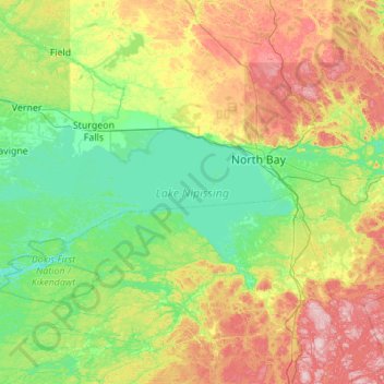
Naam: Topografische kaart Lake Nipissing, hoogte, reliëf.
Gemiddelde hoogte: 272 m
Minimale hoogte: 182 m
Maximale hoogte: 500 m
Doe een donatie
Rust jezelf uit voor je volgende avontuur:
Als Amazon-partner verdient deze site een commissie op in aanmerking komende aankopen, zonder extra kosten voor jou.
Andere topografische kaarten
Klik op een kaart om zijn topografie, zijn hoogte en zijn reliëf te bekijken.
Smoke Lake
Canada > Ontario > Nipissing District > Unorganized South Nipissing
Gemiddelde hoogte: 439 m
Doe een donatie
Rust jezelf uit voor je volgende avontuur:
Als Amazon-partner verdient deze site een commissie op in aanmerking komende aankopen, zonder extra kosten voor jou.
Doe een donatie
Rust jezelf uit voor je volgende avontuur:
Als Amazon-partner verdient deze site een commissie op in aanmerking komende aankopen, zonder extra kosten voor jou.
Arrow Lake
Canada > Ontario > Nipissing District > Unorganized South Nipissing
Gemiddelde hoogte: 414 m
Doe een donatie
Rust jezelf uit voor je volgende avontuur:
Als Amazon-partner verdient deze site een commissie op in aanmerking komende aankopen, zonder extra kosten voor jou.
Madawaska Highlands
Canada > Ontario > Nipissing District > Unorganized South Nipissing
Gemiddelde hoogte: 371 m
Doe een donatie
Rust jezelf uit voor je volgende avontuur:
Als Amazon-partner verdient deze site een commissie op in aanmerking komende aankopen, zonder extra kosten voor jou.
Princes Lake
Canada > Ontario > Nipissing District > South Algonquin Township
Gemiddelde hoogte: 467 m
Doe een donatie
Rust jezelf uit voor je volgende avontuur:
Als Amazon-partner verdient deze site een commissie op in aanmerking komende aankopen, zonder extra kosten voor jou.
Rose Lake
Canada > Ontario > Nipissing District > Unorganized South Nipissing
Gemiddelde hoogte: 459 m
Doe een donatie
Rust jezelf uit voor je volgende avontuur:
Als Amazon-partner verdient deze site een commissie op in aanmerking komende aankopen, zonder extra kosten voor jou.
Bellwood
Canada > Ontario > Nipissing District > South Algonquin Township > Whitney
Gemiddelde hoogte: 410 m
Carcajou Lake
Canada > Ontario > Nipissing District > Unorganized South Nipissing
Gemiddelde hoogte: 291 m
Gilmour Lake
Canada > Ontario > Nipissing District > Papineau-Cameron Township
Gemiddelde hoogte: 342 m
Doe een donatie
Rust jezelf uit voor je volgende avontuur:
Als Amazon-partner verdient deze site een commissie op in aanmerking komende aankopen, zonder extra kosten voor jou.
William Lake
Canada > Ontario > Nipissing District > Unorganized South Nipissing
Gemiddelde hoogte: 421 m
Rutherglen
Canada > Ontario > Nipissing District > Bonfield Township > Rutherglen
Gemiddelde hoogte: 236 m
Mizzy Lake
Canada > Ontario > Nipissing District > Unorganized South Nipissing
Gemiddelde hoogte: 459 m
Doe een donatie
Rust jezelf uit voor je volgende avontuur:
Als Amazon-partner verdient deze site een commissie op in aanmerking komende aankopen, zonder extra kosten voor jou.
Madawaska Highlands
Canada > Ontario > Nipissing District > South Algonquin Township
Gemiddelde hoogte: 442 m
Whitelily Lake
Canada > Ontario > Nipissing District > South Algonquin Township
Gemiddelde hoogte: 389 m
Gilmour Island
Canada > Ontario > Nipissing District > Unorganized South Nipissing
Gemiddelde hoogte: 339 m
Doe een donatie
Rust jezelf uit voor je volgende avontuur:
Als Amazon-partner verdient deze site een commissie op in aanmerking komende aankopen, zonder extra kosten voor jou.
Coldspring Lake
Canada > Ontario > Nipissing District > Unorganized South Nipissing
Gemiddelde hoogte: 440 m
Beau Lake
Canada > Ontario > Nipissing District > Unorganized South Nipissing
Gemiddelde hoogte: 416 m
Doe een donatie
Rust jezelf uit voor je volgende avontuur:
Als Amazon-partner verdient deze site een commissie op in aanmerking komende aankopen, zonder extra kosten voor jou.
Thistle Lake
Canada > Ontario > Nipissing District > Unorganized South Nipissing
Gemiddelde hoogte: 459 m
Windermere Lake
Canada > Ontario > Nipissing District > Unorganized South Nipissing
Gemiddelde hoogte: 355 m
Doe een donatie
Rust jezelf uit voor je volgende avontuur:
Als Amazon-partner verdient deze site een commissie op in aanmerking komende aankopen, zonder extra kosten voor jou.