
Topografische kaart Schwarzsee
Interactieve kaart
Klik op de kaart om de hoogte weer te geven.
Over deze kaart
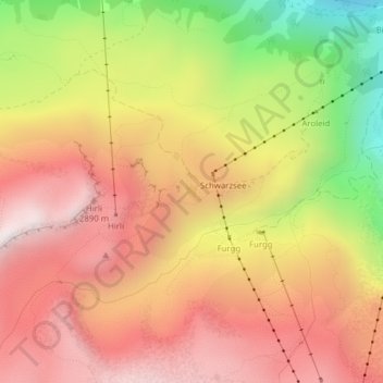
Naam: Topografische kaart Schwarzsee, hoogte, reliëf.
Gemiddelde hoogte: 2.499 m
Minimale hoogte: 1.864 m
Maximale hoogte: 2.933 m
Andere topografische kaarten
Klik op een kaart om zijn topografie, zijn hoogte en zijn reliëf te bekijken.
Dufourspitze (Monte Rosa)
Dufourspitze (Monte Rosa), Zermatt, Visp, Wallis, 3920, Schweiz
Gemiddelde hoogte: 4.033 m
Parrotspitze
Parrotspitze, Zermatt, Visp, Wallis, 3920, Schweiz
Gemiddelde hoogte: 3.887 m
Durandgletscher
Durandgletscher, Arbengrat, Chalbermatten, Zermatt, Visp, Wallis, 3920, Schweiz
Gemiddelde hoogte: 3.163 m
Liskamm westlicher Vorgipfel
Liskamm westlicher Vorgipfel, Zermatt, Visp, Wallis, 3920, Schweiz
Gemiddelde hoogte: 3.813 m
Zumsteinspitze
Zumsteinspitze, Zermatt, Visp, Wallis, 3920, Schweiz
Gemiddelde hoogte: 4.001 m
Unterrothorn
Unterrothorn, Zermatt, Visp, Wallis, 3920, Schweiz
Gemiddelde hoogte: 2.715 m