
Topografische kaart Villa La Angostura
Interactieve kaart
Klik op de kaart om de hoogte weer te geven.
Villa La Angostura
The elevation of the city centre is about 790 m, the lake is at 765 m. Surrounding mountains range from 1,500 m to about 2,000 m (Cerro Bayo, right behind the city, is 1,782 m high).
Over deze kaart
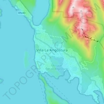
Naam: Topografische kaart Villa La Angostura, hoogte, reliëf.
Gemiddelde hoogte: 921 m
Minimale hoogte: 759 m
Maximale hoogte: 1.824 m