
Topografische kaart Gresham
Interactieve kaart
Klik op de kaart om de hoogte weer te geven.
Over deze kaart
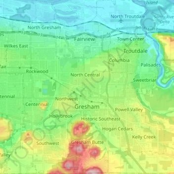
Naam: Topografische kaart Gresham, hoogte, reliëf.
Locatie: Gresham, Multnomah County, Oregon, United States (45.46094 -122.49807 45.56088 -122.36758)
Gemiddelde hoogte: 90 m
Minimale hoogte: -2 m
Maximale hoogte: 322 m
Though much of Gresham is relatively flat, it is characterized by a hill on its eastern border. Northeast Gresham is also hilly, particularly where the city meets Troutdale toward the Columbia River. Its elevation is 325 feet (99 m). Johnson Creek, which begins at the foothills of the Cascade Mountains, runs westward through Gresham, with 23 percent of the creek's watershed running through the city.
Andere topografische kaarten
Klik op een kaart om zijn topografie, zijn hoogte en zijn reliëf te bekijken.
Portland
United States > Oregon > Multnomah County
Portland, Multnomah County, Oregon, United States
Gemiddelde hoogte: 77 m
Corbett
United States > Oregon > Multnomah County
Corbett, Multnomah County, Oregon, 97019, United States
Gemiddelde hoogte: 127 m
Sauvie Island
United States > Oregon > Multnomah County
Sauvie Island, Multnomah County, Oregon, United States
Gemiddelde hoogte: 157 m
Troutdale
United States > Oregon > Multnomah County
Troutdale, Multnomah County, Oregon, 97060, United States
Gemiddelde hoogte: 54 m
Pearl District
United States > Oregon > Multnomah County > Portland
Pearl District, Portland, Multnomah County, Oregon, United States
Gemiddelde hoogte: 25 m
East Columbia
United States > Oregon > Multnomah County > Portland
East Columbia, Portland, Multnomah County, Oregon, United States
Gemiddelde hoogte: 9 m