
Topografische kaart Gatton
Klik op de kaart om de hoogte weer te geven.
Gatton
Gatton's elevations range from 215m AOD, the highest elevation, along Fort Lane, a cul-de-sac off the intersection of Reigate Hill (M25 Junction 8) which leads to four homes over the boundary in Reigate, a radio transmitter station, and a water tower. On the A217 is the Bridge House Hotel, whose name refers to a footbridge carrying the North Downs Way across the A217 85m to the east.
Over deze kaart
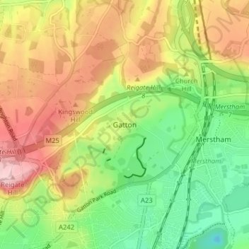
Naam: Topografische kaart Gatton, hoogte, reliëf.
Gemiddelde hoogte: 134 m
Minimale hoogte: 46 m
Maximale hoogte: 236 m
Andere topografische kaarten
Klik op een kaart om zijn topografie, zijn hoogte en zijn reliëf te bekijken.
Lower Earlswood Lake
United Kingdom > England > Surrey > Reigate and Banstead > Redhill
Gemiddelde hoogte: 75 m
Redhill Common
United Kingdom > England > Surrey > Reigate and Banstead > Redhill
Gemiddelde hoogte: 92 m
Banstead Wood
United Kingdom > England > Surrey > Reigate and Banstead > Chipstead
Gemiddelde hoogte: 145 m
Reigate Park
United Kingdom > England > Surrey > Reigate and Banstead > Reigate
Gemiddelde hoogte: 80 m
Horley
United Kingdom > England > Surrey > Reigate and Banstead
Horley is at an altitude of around 54 m (177 ft) above mean sea level.
Gemiddelde hoogte: 58 m