
Topografische kaart Masméjean
Interactieve kaart
Klik op de kaart om de hoogte weer te geven.
Over deze kaart
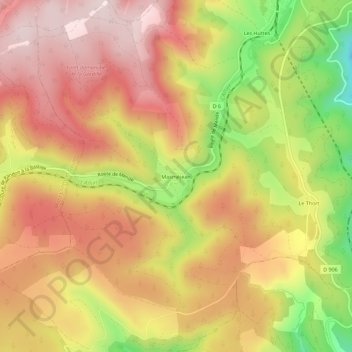
Naam: Topografische kaart Masméjean, hoogte, reliëf.
Gemiddelde hoogte: 1.143 m
Minimale hoogte: 890 m
Maximale hoogte: 1.311 m
Andere topografische kaarten
Klik op een kaart om zijn topografie, zijn hoogte en zijn reliëf te bekijken.
Les Huttes
France > Occitanie > Lozère > La Bastide-Puylaurent > La Bastide
Les Huttes, La Bastide, La Bastide-Puylaurent, Mende, Lozère, Occitanie, France métropolitaine, 48250, France
Gemiddelde hoogte: 1.088 m
La Bastide
France > Occitanie > Lozère > La Bastide-Puylaurent
La Bastide, La Bastide-Puylaurent, Mende, Lozère, Occitanie, France métropolitaine, 48250, France
Gemiddelde hoogte: 1.084 m
Puylaurent
France > Occitanie > Lozère > La Bastide-Puylaurent
Puylaurent, La Bastide-Puylaurent, Mende, Lozère, Occitanie, France métropolitaine, 48250, France
Gemiddelde hoogte: 1.055 m