
Topografische kaart Audubon Society
Interactieve kaart
Klik op de kaart om de hoogte weer te geven.
Over deze kaart
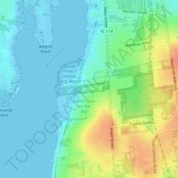
Naam: Topografische kaart Audubon Society, hoogte, reliëf.
Gemiddelde hoogte: 14 m
Minimale hoogte: -6 m
Maximale hoogte: 44 m
Andere topografische kaarten
Klik op een kaart om zijn topografie, zijn hoogte en zijn reliëf te bekijken.
Snake Den
USA > Rhode Island > Johnston
Snake Den, Johnston, Providence, Rhode Island, 02919, USA
Gemiddelde hoogte: 90 m
Beavertail State Park
USA > Rhode Island > Jamestown
Beavertail State Park, Jamestown, Newport, Rhode Island, USA
Gemiddelde hoogte: 2 m
Killingly Pond
USA > Rhode Island > Glocester
Killingly Pond, Dam Road, Glocester, Windham County, Rhode Island, 06243, USA
Gemiddelde hoogte: 193 m
Ninigret National Wildlife Refuge
USA > Rhode Island > Charlestown
Ninigret National Wildlife Refuge, Charlestown, Washington, Rhode Island, USA
Gemiddelde hoogte: 1 m
Narragansett Bay National Estuarine Research Reserve
USA > Rhode Island > Portsmouth
Narragansett Bay National Estuarine Research Reserve, 55, Portsmouth, Newport, Rhode Island, 02872, USA
Gemiddelde hoogte: 10 m
Rhode Island Sound
USA > Rhode Island > Little Compton
Rhode Island Sound, Rhode Island Road, Little Compton, Newport, Rhode Island, 02837, USA
Gemiddelde hoogte: 0 m
Badger Mountain
USA > Rhode Island > Burrillville
Badger Mountain, Burrillville, Providence, Rhode Island, USA
Gemiddelde hoogte: 190 m
Norman Bird Sanctuary
USA > Rhode Island > Middletown
Norman Bird Sanctuary, Middletown, Newport, Rhode Island, 02842, USA
Gemiddelde hoogte: 16 m