
Topografische kaart Village of Alfred
Interactieve kaart
Klik op de kaart om de hoogte weer te geven.
Over deze kaart
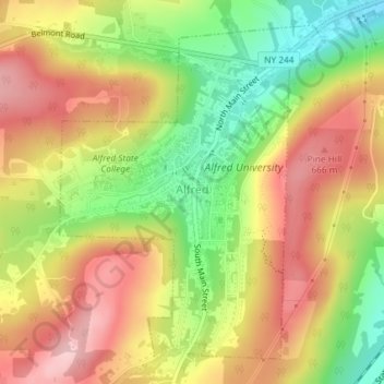
Naam: Topografische kaart Village of Alfred, hoogte, reliëf.
Gemiddelde hoogte: 597 m
Minimale hoogte: 494 m
Maximale hoogte: 686 m
According to the United States Census Bureau, the village has a total area of 1.2 square miles (3.1 km2), all land. A small stream, Kanakadea Creek, flows through the center of the village, then to the Canisteo River, part of the Susquehanna River watershed. The topography is steep hill country, part of the Allegheny Plateau, a physiographic region that is part of the Appalachian Mountains.
Andere topografische kaarten
Klik op een kaart om zijn topografie, zijn hoogte en zijn reliëf te bekijken.
Town of Grove
United States > New York > Allegany County
Town of Grove, Allegany County, New York, 14884, United States
Gemiddelde hoogte: 563 m
Town of Birdsall
United States > New York > Allegany County
Town of Birdsall, Allegany County, New York, United States
Gemiddelde hoogte: 581 m
Town of Wellsville
United States > New York > Allegany County
Town of Wellsville, Allegany County, New York, 14895, United States
Gemiddelde hoogte: 564 m
Village of Andover
United States > New York > Allegany County
Village of Andover, Town of Andover, Allegany County, New York, 14806, United States
Gemiddelde hoogte: 561 m
Town of Rushford
United States > New York > Allegany County
Town of Rushford, Allegany County, New York, United States
Gemiddelde hoogte: 528 m
Swain
United States > New York > Allegany County
Swain, Town of Grove, Allegany County, New York, 14884, United States
Gemiddelde hoogte: 503 m
Almond
United States > New York > Allegany County > Almond
Almond, Allegany County, New York, United States
Gemiddelde hoogte: 470 m
Birdsall
United States > New York > Allegany County
Birdsall, Town of Birdsall, Allegany County, New York, United States
Gemiddelde hoogte: 582 m