
Topografische kaart Pukanec
Interactieve kaart
Klik op de kaart om de hoogte weer te geven.
Over deze kaart
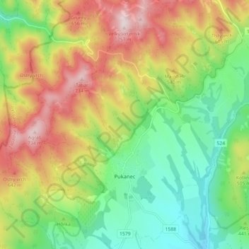
Naam: Topografische kaart Pukanec, hoogte, reliëf.
Gemiddelde hoogte: 462 m
Minimale hoogte: 259 m
Maximale hoogte: 743 m
The village lies at an altitude of 354 metres and covers an area of 26.196 km2. It has a population of 2067 people. It is located near the Štiavnica Mountains, in the Sikenica river valley. It is located around 18 km northeast of Levice.
Andere topografische kaarten
Klik op een kaart om zijn topografie, zijn hoogte en zijn reliëf te bekijken.
Nový Tekov
Slovakia > Region of Nitra > District of Levice
Nový Tekov, District of Levice, Region of Nitra, Western Slovakia, 935 33, Slovakia
Gemiddelde hoogte: 176 m
Veľký Ďur
Slovakia > Region of Nitra > District of Levice
Veľký Ďur, District of Levice, Region of Nitra, Western Slovakia, 935 34, Slovakia
Gemiddelde hoogte: 192 m