
Topografische kaart Harris Neck National Wildlife Refuge
Interactieve kaart
Klik op de kaart om de hoogte weer te geven.
Over deze kaart
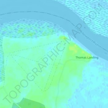
Naam: Topografische kaart Harris Neck National Wildlife Refuge, hoogte, reliëf.
Gemiddelde hoogte: 3 m
Minimale hoogte: -3 m
Maximale hoogte: 13 m
Andere topografische kaarten
Klik op een kaart om zijn topografie, zijn hoogte en zijn reliëf te bekijken.
Black Island
United States > Georgia > McIntosh County
Black Island, McIntosh County, Georgia, United States
Gemiddelde hoogte: 2 m
Darien
United States > Georgia > McIntosh County
Darien, McIntosh County, Georgia, 31305, United States
Gemiddelde hoogte: 3 m
Blackbeard Island
United States > Georgia > McIntosh County
Blackbeard Island, McIntosh County, Georgia, United States
Gemiddelde hoogte: 2 m
Pico Island
United States > Georgia > McIntosh County > Darien
Pico Island, Darien, McIntosh County, Georgia, 31305, United States
Gemiddelde hoogte: 4 m