
Topografische kaart Whitecross
Interactieve kaart
Klik op de kaart om de hoogte weer te geven.
Over deze kaart
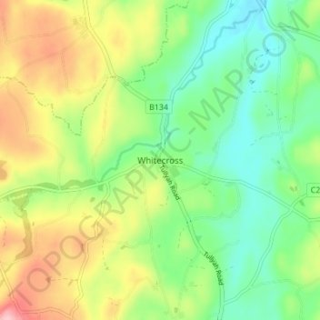
Naam: Topografische kaart Whitecross, hoogte, reliëf.
Gemiddelde hoogte: 127 m
Minimale hoogte: 65 m
Maximale hoogte: 225 m
Andere topografische kaarten
Klik op een kaart om zijn topografie, zijn hoogte en zijn reliëf te bekijken.
Killyberry Boyd
United Kingdom > Northern Ireland
Killyberry Boyd, Northern Ireland, United Kingdom
Gemiddelde hoogte: 35 m
Hilltown
United Kingdom > Northern Ireland > County Down
Hilltown, County Down, Northern Ireland, BT34 5UH, United Kingdom
Gemiddelde hoogte: 136 m
Newcastle Road
United Kingdom > Northern Ireland
Newcastle Road, Northern Ireland, United Kingdom
Gemiddelde hoogte: 8 m
Newtownards
United Kingdom > Northern Ireland > County Down
Newtownards, County Down, Northern Ireland, BT23 4FA, United Kingdom
Gemiddelde hoogte: 50 m
Whiterock
United Kingdom > Northern Ireland > County Down
Whiterock, County Down, Northern Ireland, BT23 6QH, United Kingdom
Gemiddelde hoogte: 11 m
Binian Lough
United Kingdom > Northern Ireland > County Down
Binian Lough, County Down, Northern Ireland, United Kingdom
Gemiddelde hoogte: 411 m
Clough
United Kingdom > Northern Ireland > County Down
Clough, County Down, Ulster, Northern Ireland, BT30 8RB, United Kingdom
Gemiddelde hoogte: 32 m
Belfast
United Kingdom > Northern Ireland > County Antrim
Belfast, County Antrim, Northern Ireland, United Kingdom
Gemiddelde hoogte: 92 m
Cave Hill
United Kingdom > Northern Ireland > County Antrim > Belfast
Cave Hill, Greencastle, Belfast, County Antrim, Northern Ireland, BT15 5GL, United Kingdom
Gemiddelde hoogte: 172 m
Giant's Causeway
United Kingdom > Northern Ireland > County Antrim
Giant's Causeway, County Antrim, Ulster, Northern Ireland, United Kingdom
Gemiddelde hoogte: 26 m
West Division
United Kingdom > Northern Ireland
West Division, Northern Ireland, United Kingdom
Gemiddelde hoogte: 128 m
Crossmaglen
United Kingdom > Northern Ireland
Crossmaglen, Newry, Mourne and Down District Council, Northern Ireland, United Kingdom
Gemiddelde hoogte: 123 m
Cappagh
United Kingdom > Northern Ireland
Cappagh, Northern Ireland, United Kingdom
Gemiddelde hoogte: 234 m
Drumragh (Caldwell)
United Kingdom > Northern Ireland > County Tyrone
Drumragh (Caldwell), County Tyrone, Ulster, Northern Ireland, United Kingdom
Gemiddelde hoogte: 87 m
Dungannon
United Kingdom > Northern Ireland > County Tyrone
Dungannon, County Tyrone, Northern Ireland, BT70 1BD, United Kingdom
Gemiddelde hoogte: 76 m
Carryduff
United Kingdom > Northern Ireland > County Down
Carryduff, County Down, Ulster, Northern Ireland, BT8 8DN, United Kingdom
Gemiddelde hoogte: 110 m
Portadown
United Kingdom > Northern Ireland > County Armagh
Portadown, County Armagh, Ulster, Northern Ireland, BT62 1BF, United Kingdom
Gemiddelde hoogte: 28 m
Loughgall
United Kingdom > Northern Ireland > County Armagh
Loughgall, County Armagh, Ulster, Northern Ireland, BT61 8HY, United Kingdom
Gemiddelde hoogte: 32 m
Belcoo
United Kingdom > Northern Ireland > County Fermanagh
Belcoo, County Fermanagh, Ulster, Northern Ireland, BT93 5FB, United Kingdom
Gemiddelde hoogte: 86 m
Ahoghill
United Kingdom > Northern Ireland > County Antrim
Ahoghill, County Antrim, Ulster, Northern Ireland, BT42 1JZ, United Kingdom
Gemiddelde hoogte: 84 m
Moher
United Kingdom > Northern Ireland > County Fermanagh
Moher, Lea, County Fermanagh, Ulster, Northern Ireland, BT92 4FJ, United Kingdom
Gemiddelde hoogte: 65 m
Aughnahoory
United Kingdom > Northern Ireland > County Down > Kilkeel
Aughnahoory, Kilkeel, County Down, Ulster, Northern Ireland, United Kingdom
Gemiddelde hoogte: 60 m
County Armagh
United Kingdom > Northern Ireland
County Armagh, Ulster, Northern Ireland, United Kingdom
Gemiddelde hoogte: 98 m
County Londonderry
United Kingdom > Northern Ireland
County Londonderry, Ulster, Northern Ireland, United Kingdom
Gemiddelde hoogte: 128 m
Mourne Mountains Middle
United Kingdom > Northern Ireland
Mourne Mountains Middle, Ulster, Northern Ireland, United Kingdom
Gemiddelde hoogte: 348 m
Tempo
United Kingdom > Northern Ireland > County Fermanagh
Tempo, County Fermanagh, Ulster, Northern Ireland, BT94 3LU, United Kingdom
Gemiddelde hoogte: 127 m
Ballyfatten
United Kingdom > Northern Ireland
Ballyfatten, Ulster, Northern Ireland, BT82 9PY, United Kingdom
Gemiddelde hoogte: 34 m
Coleraine
United Kingdom > Northern Ireland > County Londonderry
Coleraine, County Londonderry, Ulster, Northern Ireland, BT52 1EP, United Kingdom
Gemiddelde hoogte: 40 m
McLean's Hill
United Kingdom > Northern Ireland > County Down > Bryansford
McLean's Hill, Bryansford, County Down, Ulster, Northern Ireland, BT31 9HH, United Kingdom
Gemiddelde hoogte: 93 m
Carr
United Kingdom > Northern Ireland
Carr, Ulster, Northern Ireland, United Kingdom
Gemiddelde hoogte: 60 m
Horse Island
United Kingdom > Northern Ireland > County Fermanagh
Horse Island, County Fermanagh, Ulster, Northern Ireland, United Kingdom
Gemiddelde hoogte: 46 m
Armagh
United Kingdom > Northern Ireland > County Armagh > Armagh
Armagh, County Armagh, Ulster, Northern Ireland, United Kingdom
Gemiddelde hoogte: 100 m
Newry
United Kingdom > Northern Ireland > County Down > Newry
Newry, County Down, Northern Ireland, BT34 1DG, United Kingdom
Gemiddelde hoogte: 129 m
Limavady
United Kingdom > Northern Ireland > County Londonderry
Limavady, County Londonderry, Ulster, Northern Ireland, BT49 0EP, United Kingdom
Gemiddelde hoogte: 37 m
Upper Ballysillan
United Kingdom > Northern Ireland > County Antrim
Upper Ballysillan, County Antrim, Northern Ireland, United Kingdom
Gemiddelde hoogte: 254 m
Glynn
United Kingdom > Northern Ireland > County Antrim > Glynn
Glynn, County Antrim, Northern Ireland, BT40 3HF, United Kingdom
Gemiddelde hoogte: 63 m
Armagh
United Kingdom > Northern Ireland > Armagh
Armagh, County Armagh, Northern Ireland, BT61 7DJ, United Kingdom
Gemiddelde hoogte: 85 m
County Antrim
United Kingdom > Northern Ireland
County Antrim, Northern Ireland, United Kingdom
Gemiddelde hoogte: 70 m
Groomsport
United Kingdom > Northern Ireland > County Down > Groomsport
Groomsport, County Down, Northern Ireland, BT19 6JR, United Kingdom
Gemiddelde hoogte: 10 m
Newry
United Kingdom > Northern Ireland > County Down > Newry
Newry, County Down, Northern Ireland, United Kingdom
Gemiddelde hoogte: 73 m
Lough Aghery
United Kingdom > Northern Ireland
Lough Aghery, County Down, Northern Ireland, United Kingdom
Gemiddelde hoogte: 129 m
Larne
United Kingdom > Northern Ireland > County Antrim > Larne
Larne, County Antrim, Northern Ireland, BT40 1HU, United Kingdom
Gemiddelde hoogte: 54 m
Dromore
United Kingdom > Northern Ireland > County Down
Dromore, County Down, Northern Ireland, BT25 1BL, United Kingdom
Gemiddelde hoogte: 106 m
Banbridge
United Kingdom > Northern Ireland > County Down
Banbridge, County Down, Ulster, Northern Ireland, BT32 3AD, United Kingdom
Gemiddelde hoogte: 90 m
Heron Island
United Kingdom > Northern Ireland > County Fermanagh
Heron Island, County Fermanagh, Ulster, Northern Ireland, United Kingdom
Gemiddelde hoogte: 47 m
Belfast
United Kingdom > Northern Ireland > County Antrim
Belfast, County Antrim, Ulster, Northern Ireland, BT1 5GS, United Kingdom
Gemiddelde hoogte: 87 m
Annaclone
United Kingdom > Northern Ireland > Katesbridge
Annaclone, Katesbridge, County Down, Northern Ireland, United Kingdom
Gemiddelde hoogte: 107 m
White Island
United Kingdom > Northern Ireland
White Island, County Fermanagh, Northern Ireland, United Kingdom
Gemiddelde hoogte: 48 m
Lisburn
United Kingdom > Northern Ireland > County Antrim
Lisburn, County Antrim, Northern Ireland, BT28 1BJ, United Kingdom
Gemiddelde hoogte: 92 m
Cookstown
United Kingdom > Northern Ireland > County Tyrone
Cookstown, County Tyrone, Ulster, Northern Ireland, BT80 8PF, United Kingdom
Gemiddelde hoogte: 67 m