
Topografische kaart Pooley Country Park
Interactieve kaart
Klik op de kaart om de hoogte weer te geven.
Over deze kaart
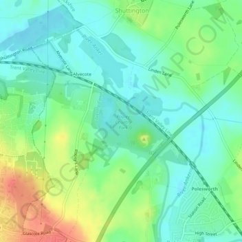
Naam: Topografische kaart Pooley Country Park, hoogte, reliëf.
Gemiddelde hoogte: 76 m
Minimale hoogte: 57 m
Maximale hoogte: 114 m
Andere topografische kaarten
Klik op een kaart om zijn topografie, zijn hoogte en zijn reliëf te bekijken.
Birchmoor
United Kingdom > England > Warwickshire > North Warwickshire > Polesworth
Birchmoor, Polesworth CP, Polesworth, North Warwickshire, Warwickshire, England, B78 1AF, United Kingdom
Gemiddelde hoogte: 93 m