
Topografische kaart Pinnacle Peak
Interactieve kaart
Klik op de kaart om de hoogte weer te geven.
Over deze kaart
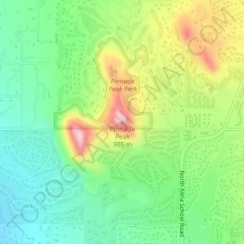
Naam: Topografische kaart Pinnacle Peak, hoogte, reliëf.
Gemiddelde hoogte: 753 m
Minimale hoogte: 658 m
Maximale hoogte: 915 m
Pinnacle Peak is a granite summit located in Scottsdale, Arizona. The peak rises to an elevation of 3,169 feet (966 m). It is located within the 150-acre (61 ha) Pinnacle Peak Park, operated by the City of Scottsdale Park District. Part of the Sonoran Desert, the park is home to a variety of native desert flora and fauna. Hikers utilize a 1.75 mile trail to explore the area, though rock climbing skills are needed to reach the summit.
Andere topografische kaarten
Klik op een kaart om zijn topografie, zijn hoogte en zijn reliëf te bekijken.
Tom's Thumb
United States > Arizona > Maricopa County > Scottsdale
Tom's Thumb, Scottsdale, Maricopa County, Arizona, United States
Gemiddelde hoogte: 981 m
Butte Peak
United States > Arizona > Maricopa County > Scottsdale
Butte Peak, Scottsdale, Maricopa County, Arizona, United States
Gemiddelde hoogte: 1.279 m
Brown's Mountain
United States > Arizona > Maricopa County > Scottsdale
Brown's Mountain, Scottsdale, Maricopa County, Arizona, 85262, United States
Gemiddelde hoogte: 827 m
Pinnacle Peak Park
United States > Arizona > Maricopa County > Scottsdale
Pinnacle Peak Park, 26802, North 102nd Way, Scottsdale, Maricopa County, Arizona, United States
Gemiddelde hoogte: 762 m