
Topografische kaart West Elmira
Interactieve kaart
Klik op de kaart om de hoogte weer te geven.
Over deze kaart
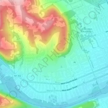
Naam: Topografische kaart West Elmira, hoogte, reliëf.
Gemiddelde hoogte: 320 m
Minimale hoogte: 255 m
Maximale hoogte: 467 m
Andere topografische kaarten
Klik op een kaart om zijn topografie, zijn hoogte en zijn reliëf te bekijken.
Brand Park
United States > New York > Chemung County > City of Elmira
Brand Park, City of Elmira, Chemung County, New York, United States
Gemiddelde hoogte: 270 m
City of Elmira
United States > New York > Chemung County > City of Elmira
City of Elmira, Ashland, Chemung County, New York, United States
Gemiddelde hoogte: 296 m
Village of Millport
United States > New York > Chemung County
Village of Millport, Town of Veteran, Chemung County, New York, United States
Gemiddelde hoogte: 296 m
Langdon Hill
United States > New York > Chemung County
Langdon Hill, Chemung County, New York, 14838, United States
Gemiddelde hoogte: 449 m
Lowman
United States > New York > Chemung County
Lowman, Town of Ashland, Chemung County, New York, 14894, United States
Gemiddelde hoogte: 290 m
Village of Horseheads
United States > New York > Chemung County
Village of Horseheads, Town of Horseheads, Veteran, Chemung County, New York, 14845, United States
Gemiddelde hoogte: 298 m