
Topografische kaart Lake Bolsena
Interactieve kaart
Klik op de kaart om de hoogte weer te geven.
Lake Bolsena
Elevations on the north of the lake are the highest, with a maximum of 702 m (2,303 ft). As the lake is at 305 m (1,001 ft), no hill is more than 397 m (1,302 ft) higher than it. On the northern rim of the caldera is San Lorenzo Nuovo ("New Saint Lawrence"), which was moved from an older site (a hypothetical San Lorenzo Vecchio, "Old Saint Lawrence") further down the slope to avoid malaria. The northern shore of the lake once featured marshes, breeding grounds for the mosquitos that carry the disease. Currently it is agricultural. At the site of old San Lorenzo are Etruscan antiquities. To the north of San Lorenzo Nuovo and the caldera rim is Acquapendente.
Over deze kaart
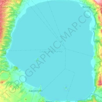
Naam: Topografische kaart Lake Bolsena, hoogte, reliëf.
Locatie: Lake Bolsena, Viterbo, Lazio, Italy (42.53325 11.85721 42.65198 11.99712)
Gemiddelde hoogte: 328 m
Minimale hoogte: 297 m
Maximale hoogte: 574 m
Andere topografische kaarten
Klik op een kaart om zijn topografie, zijn hoogte en zijn reliëf te bekijken.