
Topografische kaart Menifee County
Interactieve kaart
Klik op de kaart om de hoogte weer te geven.
Over deze kaart
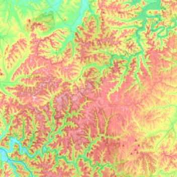
Naam: Topografische kaart Menifee County, hoogte, reliëf.
Locatie: Menifee County, Kentucky, VS (37.81840 -83.77553 38.05887 -83.43369)
Gemiddelde hoogte: 313 m
Minimale hoogte: 199 m
Maximale hoogte: 424 m
Andere topografische kaarten
Klik op een kaart om zijn topografie, zijn hoogte en zijn reliëf te bekijken.
Hodgenville
VS > Kentucky > Hodgenville
Hodgenville, Larue County, Kentucky, VS
Gemiddelde hoogte: 229 m
Nationaal park Mammoth Cave
VS > Kentucky > Mammoth Cave
Nationaal park Mammoth Cave, Green River Ferry Road, Mammoth Cave, Edmonson County, Kentucky, VS
Gemiddelde hoogte: 215 m
Abraham Lincoln Birthplace National Historic Site
VS > Kentucky > Boundary Oak
Abraham Lincoln Birthplace National Historic Site, Boundary Oak, Larue County, Kentucky, VS
Gemiddelde hoogte: 238 m
The Meadow
VS > Kentucky > The Meadow
The Meadow, Jefferson County, Kentucky, 40242, VS
Gemiddelde hoogte: 200 m