
Doe een donatie
Rust jezelf uit voor je volgende avontuur:
Als Amazon-partner verdient deze site een commissie op in aanmerking komende aankopen, zonder extra kosten voor jou.
Topografische kaart Whidbey Island
Klik op de kaart om de hoogte weer te geven.
Doe een donatie
Rust jezelf uit voor je volgende avontuur:
Als Amazon-partner verdient deze site een commissie op in aanmerking komende aankopen, zonder extra kosten voor jou.
Whidbey Island
Whidbey Island features a diverse topography characterized by a mix of rolling hills, lush forests, and dramatic coastal cliffs. The island stretches approximately 55 miles in length and up to 12 miles wide, rising to elevations of about 500 feet at its highest point. Its terrain includes expansive farmland and rugged shorelines, interspersed with sandy beaches and rocky outcrops along the Puget Sound. Deception Pass, a notable feature, consists of steep cliffs and a narrow strait that offers stunning views and is bridged by the iconic Deception Pass Bridge. The varied landscape supports a rich ecosystem, making it a haven for outdoor activities like hiking, kayaking, and wildlife observation.
Doe een donatie
Rust jezelf uit voor je volgende avontuur:
Als Amazon-partner verdient deze site een commissie op in aanmerking komende aankopen, zonder extra kosten voor jou.
Over deze kaart
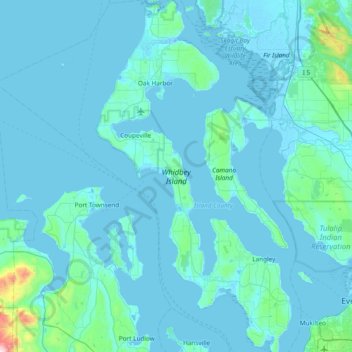
Naam: Topografische kaart Whidbey Island, hoogte, reliëf.
Locatie: Whidbey Island, Island County, Washington, United States (47.90492 -122.76999 48.41132 -122.34936)
Gemiddelde hoogte: 45 m
Minimale hoogte: -4 m
Maximale hoogte: 993 m
Doe een donatie
Rust jezelf uit voor je volgende avontuur:
Als Amazon-partner verdient deze site een commissie op in aanmerking komende aankopen, zonder extra kosten voor jou.
Andere topografische kaarten
Klik op een kaart om zijn topografie, zijn hoogte en zijn reliëf te bekijken.