
Topografische kaart Mogok
Interactieve kaart
Klik op de kaart om de hoogte weer te geven.
Over deze kaart
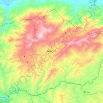
Naam: Topografische kaart Mogok, hoogte, reliëf.
Locatie: Mogok, Pyin Oo Lwin District, Mandalay, 05091, Myanmar (22.76270 96.34514 23.08270 96.66514)
Gemiddelde hoogte: 993 m
Minimale hoogte: 173 m
Maximale hoogte: 2.235 m
At 1170 meters in elevation, the city has a fairly temperate climate year-round, and is home to Bamar, Shan, Lisu, Palaung, and Karen ethnic groups, as well as Chinese, Indians and Gurkhas. The city is composed of two towns, Mogok and Kyat Pyin. Mogok is four miles long and two miles wide. It is situated in a valley surrounded by a large number of mountains. Kyat Pyin lies about 7 miles SW of Mogok. Tourists that travel to this area need a special authorization and a guide person.