
Topografische kaart Saint-Samson-de-Bonfossé
Interactieve kaart
Klik op de kaart om de hoogte weer te geven.
Over deze kaart
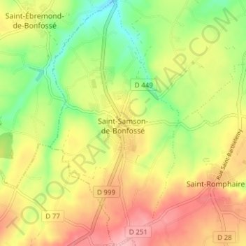
Naam: Topografische kaart Saint-Samson-de-Bonfossé, hoogte, reliëf.
Gemiddelde hoogte: 95 m
Minimale hoogte: 31 m
Maximale hoogte: 158 m
Andere topografische kaarten
Klik op een kaart om zijn topografie, zijn hoogte en zijn reliëf te bekijken.
La Mabilière
France > Normandie > Manche > Bourgvallées > Saint-Samson-de-Bonfossé
La Mabilière, Saint-Samson-de-Bonfossé, Bourgvallées, Saint-Lô, Manche, Normandie, France métropolitaine, 50750, France
Gemiddelde hoogte: 93 m
Saint-Romphaire
France > Normandie > Manche > Bourgvallées > Saint-Romphaire
Saint-Romphaire, Bourgvallées, Saint-Lô, Manche, Normandie, France métropolitaine, 50750, France
Gemiddelde hoogte: 99 m
Village de la Pasquerie
France > Normandie > Manche > Bourgvallées > Saint-Samson-de-Bonfossé
Village de la Pasquerie, Saint-Samson-de-Bonfossé, Bourgvallées, Saint-Lô, Manche, Normandie, France métropolitaine, 50750, France
Gemiddelde hoogte: 104 m
La Mancellière-sur-Vire
France > Normandie > Manche > Bourgvallées
La Mancellière-sur-Vire, Bourgvallées, Saint-Lô, Manche, Normandie, France métropolitaine, 50750, France
Gemiddelde hoogte: 56 m
Soulles
France > Normandie > Manche > Bourgvallées
Soulles, Bourgvallées, Saint-Lô, Manche, Normandie, France métropolitaine, 50750, France
Gemiddelde hoogte: 121 m