
Topografische kaart Addenbroke Island Lighthouse
Interactieve kaart
Klik op de kaart om de hoogte weer te geven.
Over deze kaart
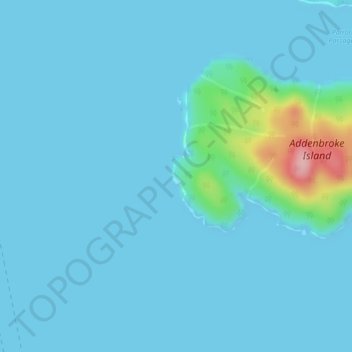
Naam: Topografische kaart Addenbroke Island Lighthouse, hoogte, reliëf.
Gemiddelde hoogte: 14 m
Minimale hoogte: 0 m
Maximale hoogte: 155 m
Andere topografische kaarten
Klik op een kaart om zijn topografie, zijn hoogte en zijn reliëf te bekijken.
Owikeno Lake
Canada > British Columbia > Central Coast Regional District > Area A (Ocean Falls/Outer Coast)
Owikeno Lake, Area A (Ocean Falls/Outer Coast), Central Coast Regional District, British Columbia, Canada
Gemiddelde hoogte: 258 m
Triquet Island
Canada > British Columbia > Central Coast Regional District > Area A (Ocean Falls/Outer Coast)
Triquet Island, Area A (Ocean Falls/Outer Coast), Central Coast Regional District, British Columbia, Canada
Gemiddelde hoogte: 3 m
Rivers Inlet
Canada > British Columbia > Central Coast Regional District > Area A (Ocean Falls/Outer Coast)
Rivers Inlet, Area A (Ocean Falls/Outer Coast), Central Coast Regional District, British Columbia, Canada
Gemiddelde hoogte: 267 m