
Topografische kaart Welland
Klik op de kaart om de hoogte weer te geven.
Over deze kaart
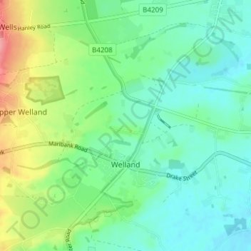
Naam: Topografische kaart Welland, hoogte, reliëf.
Gemiddelde hoogte: 51 m
Minimale hoogte: 22 m
Maximale hoogte: 121 m
Andere topografische kaarten
Klik op een kaart om zijn topografie, zijn hoogte en zijn reliëf te bekijken.
Malvern
United Kingdom > England > Worcestershire > Malvern Hills
Malvern lies in the Lower Severn/Avon plain affording it a degree of shelter caused by virtue of its nestling in between the Cotswold hills to the east, the Welsh Hills and Mountains to the west, and Birmingham plateau to the north. Although as with all the British Isles it has a maritime climate, the local…
Gemiddelde hoogte: 95 m
The Hill, Abberley
United Kingdom > England > Worcestershire > Malvern Hills > Abberley
Gemiddelde hoogte: 132 m
Upper Broadheath
United Kingdom > England > Worcestershire > Malvern Hills > Crown East
Gemiddelde hoogte: 44 m
Kerswell Green
United Kingdom > England > Worcestershire > Malvern Hills > Kempsey
Gemiddelde hoogte: 25 m
Corse Lawn
United Kingdom > England > Worcestershire > Malvern Hills > Eldersfield
Gemiddelde hoogte: 26 m
Elms Green
United Kingdom > England > Worcestershire > Malvern Hills > Abberley
Gemiddelde hoogte: 121 m
Table Hill
United Kingdom > England > Worcestershire > Malvern Hills
Table Hill is situated in the range of Malvern Hills that runs about 13 kilometres (8 mi) north-south along the Herefordshire-Worcestershire border. It lies between North Hill and Sugarloaf Hill and has an elevation of 373 metres (1,224 ft).
Gemiddelde hoogte: 188 m
Malvern
United Kingdom > England > Worcestershire > Malvern Hills
Malvern lies in the Lower Severn/Avon plain affording it a degree of shelter caused by virtue of its nestling in between the Cotswold hills to the east, the Welsh Hills and Mountains to the west, and Birmingham plateau to the north. Although as with all the British Isles it has a maritime climate, the local…
Gemiddelde hoogte: 95 m
Worcestershire Beacon
United Kingdom > England > Worcestershire > Malvern Hills
Gemiddelde hoogte: 197 m
Malvern
United Kingdom > England > Worcestershire > Malvern Hills
Malvern lies in the Lower Severn/Avon plain affording it a degree of shelter caused by virtue of its nestling in between the Cotswold hills to the east, the Welsh Hills and Mountains to the west, and Birmingham plateau to the north. Although as with all the British Isles it has a maritime climate, the local…
Gemiddelde hoogte: 95 m