
Topografische kaart Madill
Interactieve kaart
Klik op de kaart om de hoogte weer te geven.
Over deze kaart
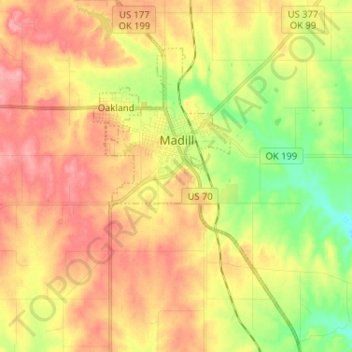
Naam: Topografische kaart Madill, hoogte, reliëf.
Locatie: Madill, Marshall County, Oklahoma, 73446, United States (34.02561 -96.79837 34.13279 -96.72625)
Gemiddelde hoogte: 248 m
Minimale hoogte: 198 m
Maximale hoogte: 290 m
There is also a small municipal airport (FAA code 1F4) named Madill Municipal Airport, 3 miles (4.8 km) northwest of the city. It has one asphalt runway, 18/36, that is 3,000 feet (910 m) by 60 feet (18 m) at elevation 862 feet (263 m). The airport beacon operates between sunrise and sunset every day. There is no control tower.
Andere topografische kaarten
Klik op een kaart om zijn topografie, zijn hoogte en zijn reliëf te bekijken.
Lake Texoma
United States > Oklahoma > Marshall County
Lake Texoma, Marshall County, Oklahoma, United States
Gemiddelde hoogte: 213 m
Antioch
United States > Oklahoma > Marshall County
Antioch, Marshall County, Oklahoma, United States
Gemiddelde hoogte: 269 m
Kingston
United States > Oklahoma > Marshall County
Kingston, Marshall County, Oklahoma, United States
Gemiddelde hoogte: 239 m
Cumberland
United States > Oklahoma > Marshall County > Cumberland
Cumberland, Marshall County, Oklahoma, United States
Gemiddelde hoogte: 212 m