
Doe een donatie
Rust jezelf uit voor je volgende avontuur:
Als Amazon-partner verdient deze site een commissie op in aanmerking komende aankopen, zonder extra kosten voor jou.
Topografische kaart Mount Arayat
Klik op de kaart om de hoogte weer te geven.
Doe een donatie
Rust jezelf uit voor je volgende avontuur:
Als Amazon-partner verdient deze site een commissie op in aanmerking komende aankopen, zonder extra kosten voor jou.
Mount Arayat
Mount Arayat stands in the middle of the flat Central Luzon Plain, consisting of rice paddies and a typical elevation of about 15 to 35 metres MSL. The mountain is topped by a circular volcanic crater about 1.2 kilometres (0.75 mi) in diameter, much of which has collapsed on the western and part of the northern rim due to erosion. This has resulted in a breached crater which opens in a west-northwest direction. This area is the apparent source of a major debris-avalanche deposit that forms hummocky terrain beyond the west and northwest sides of the volcano. The 1,026-metre (3,366 ft) summit stands on the northeast side of the breached crater, known as North Peak, while the 984-metre (3,228 ft) Pinnacle Peak is located on the southeast crater rim. Post-collapse activity formed an andesitic lava dome known as White Rock in the collapse amphitheater.
Doe een donatie
Rust jezelf uit voor je volgende avontuur:
Als Amazon-partner verdient deze site een commissie op in aanmerking komende aankopen, zonder extra kosten voor jou.
Over deze kaart
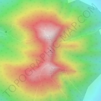
Naam: Topografische kaart Mount Arayat, hoogte, reliëf.
Locatie: Mount Arayat, Arayat, Pampanga, Central Luzon, Philippines (15.20124 120.74306 15.20134 120.74316)
Gemiddelde hoogte: 639 m
Minimale hoogte: 246 m
Maximale hoogte: 995 m
Doe een donatie
Rust jezelf uit voor je volgende avontuur:
Als Amazon-partner verdient deze site een commissie op in aanmerking komende aankopen, zonder extra kosten voor jou.
Andere topografische kaarten
Klik op een kaart om zijn topografie, zijn hoogte en zijn reliëf te bekijken.