
Topografische kaart Mainaschaff
Interactieve kaart
Klik op de kaart om de hoogte weer te geven.
Over deze kaart
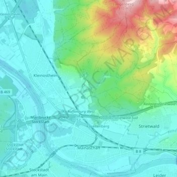
Naam: Topografische kaart Mainaschaff, hoogte, reliëf.
Locatie: Mainaschaff, Landkreis Aschaffenburg, Bavaria, 63814, Germany (49.97312 9.06484 50.02655 9.11246)
Gemiddelde hoogte: 155 m
Minimale hoogte: 101 m
Maximale hoogte: 349 m
Andere topografische kaarten
Klik op een kaart om zijn topografie, zijn hoogte en zijn reliëf te bekijken.
Wasserlos
Germany > Bavaria > Landkreis Aschaffenburg
Wasserlos, Alzenau, Landkreis Aschaffenburg, Bavaria, 63755, Germany
Gemiddelde hoogte: 185 m
Heimbach
Germany > Bavaria > Landkreis Aschaffenburg
Heimbach, Mömbris, Landkreis Aschaffenburg, Bavaria, 63776, Germany
Gemiddelde hoogte: 259 m
Großostheim
Germany > Bavaria > Landkreis Aschaffenburg
Großostheim, Landkreis Aschaffenburg, Bavaria, 63762, Germany
Gemiddelde hoogte: 148 m
Weisserstein
Germany > Bavaria > Landkreis Aschaffenburg > Rothenbucher Forst
Weisserstein, Rothenbucher Forst, Landkreis Aschaffenburg, Bavaria, 63860, Germany
Gemiddelde hoogte: 429 m