
Topografische kaart Kingscote
Interactieve kaart
Klik op de kaart om de hoogte weer te geven.
Over deze kaart
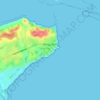
Naam: Topografische kaart Kingscote, hoogte, reliëf.
Gemiddelde hoogte: 7 m
Minimale hoogte: 0 m
Maximale hoogte: 68 m
Andere topografische kaarten
Klik op een kaart om zijn topografie, zijn hoogte en zijn reliëf te bekijken.
Kangaroo Island
Australia > South Australia > Kangaroo Island Council
Kangaroo Island, Kangaroo Island Council, South Australia, Australia
Gemiddelde hoogte: 22 m
Flinders Chase
Australia > South Australia > Kangaroo Island Council
Flinders Chase, Kangaroo Island Council, South Australia, 5223, Australia
Gemiddelde hoogte: 94 m
American River
Australia > South Australia > Kangaroo Island Council
American River, Kangaroo Island Council, South Australia, 5221, Australia
Gemiddelde hoogte: 30 m
Wisanger
Australia > South Australia > Kangaroo Island Council
Wisanger, Kangaroo Island Council, South Australia, 5223, Australia
Gemiddelde hoogte: 38 m
Cape Willoughby Conservation Park
Australia > South Australia > Kangaroo Island Council
Cape Willoughby Conservation Park, Kangaroo Island Council, South Australia, Australia
Gemiddelde hoogte: 12 m
Nepean Bay
Australia > South Australia > Kangaroo Island Council
Nepean Bay, Kangaroo Island Council, South Australia, 5223, Australia
Gemiddelde hoogte: 25 m