
Topografische kaart Crab Orchard
Interactieve kaart
Klik op de kaart om de hoogte weer te geven.
Over deze kaart
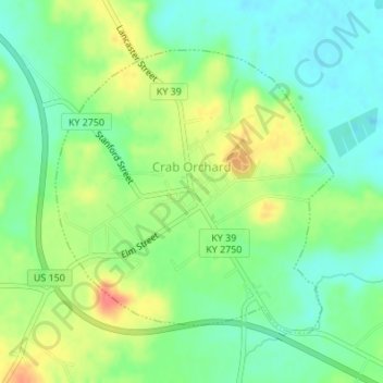
Naam: Topografische kaart Crab Orchard, hoogte, reliëf.
Locatie: Crab Orchard, Lincoln County, Kentucky, United States (37.45277 -84.51873 37.47277 -84.49392)
Gemiddelde hoogte: 283 m
Minimale hoogte: 259 m
Maximale hoogte: 319 m
Andere topografische kaarten
Klik op een kaart om zijn topografie, zijn hoogte en zijn reliëf te bekijken.
Hustonville
United States > Kentucky > Lincoln County
Hustonville, Lincoln County, Kentucky, United States
Gemiddelde hoogte: 316 m
Stanford
United States > Kentucky > Lincoln County
Stanford, Lincoln County, Kentucky, United States
Gemiddelde hoogte: 292 m
Kings Mountain
United States > Kentucky > Lincoln County
Kings Mountain, Lincoln County, Kentucky, 40442, United States
Gemiddelde hoogte: 375 m
Blue Lick
United States > Kentucky > Lincoln County
Blue Lick, Lincoln County, Kentucky, 40484, United States
Gemiddelde hoogte: 336 m
logan hubble park
United States > Kentucky > Lincoln County
logan hubble park, Lincoln County, Kentucky, United States
Gemiddelde hoogte: 267 m