
Topografische kaart Briançon
Interactieve kaart
Klik op de kaart om de hoogte weer te geven.
Over deze kaart
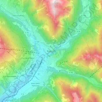
Naam: Topografische kaart Briançon, hoogte, reliëf.
Gemiddelde hoogte: 1.635 m
Minimale hoogte: 1.150 m
Maximale hoogte: 2.606 m
Due to its elevation, Briançon features a warm-summer humid continental climate (Köppen. Dfb), bordering on an oceanic climate (Cfb) under the Köppen system. Summers are warm with cool nights, and winters are cold and snowy.