
Topografische kaart Tonatico
Interactieve kaart
Klik op de kaart om de hoogte weer te geven.
Tonatico
Tonatico has several nearby mountains, including La Cruz and Tapachichi. The largest is La Puerta at 1,685 meters of elevation. The Salto de Zumpantitlán waterfall is nearby, along with the Tenancingo, San Geronimo and Taplalla rivers.
Over deze kaart
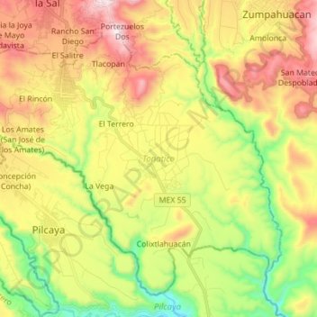
Naam: Topografische kaart Tonatico, hoogte, reliëf.
Locatie: Tonatico, State of Mexico, Mexico (18.72033 -99.71230 18.83346 -99.57373)
Gemiddelde hoogte: 1.617 m
Minimale hoogte: 1.201 m
Maximale hoogte: 2.105 m