
Topografische kaart Strawberry Point
Interactieve kaart
Klik op de kaart om de hoogte weer te geven.
Over deze kaart
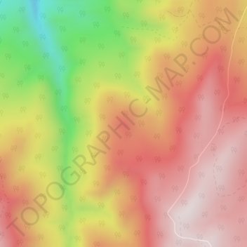
Naam: Topografische kaart Strawberry Point, hoogte, reliëf.
Locatie: Strawberry Point, Iron County, Utah, 84772, United States (37.75104 -112.94305 37.75114 -112.94295)
Gemiddelde hoogte: 2.436 m
Minimale hoogte: 2.031 m
Maximale hoogte: 2.690 m
Andere topografische kaarten
Klik op een kaart om zijn topografie, zijn hoogte en zijn reliëf te bekijken.
Cedar City
United States > Utah > Iron County
Cedar City, Iron County, Utah, United States
Gemiddelde hoogte: 1.975 m
Paragonah
United States > Utah > Iron County
Paragonah, Iron County, Utah, 84760, United States
Gemiddelde hoogte: 1.801 m
The Three Peaks
United States > Utah > Iron County
The Three Peaks, Iron County, Utah, United States
Gemiddelde hoogte: 1.789 m
Brian Head
United States > Utah > Iron County
Brian Head, Iron County, Utah, 84719, United States
Gemiddelde hoogte: 3.031 m
Cedar Breaks
United States > Utah > Iron County
Cedar Breaks, Iron County, Utah, United States
Gemiddelde hoogte: 2.843 m
Newcastle
United States > Utah > Iron County
Newcastle, Iron County, Utah, United States
Gemiddelde hoogte: 1.640 m
Cedar City
United States > Utah > Iron County > Cedar City > Cedar City
Cedar City, Iron County, Utah, 84720, United States
Gemiddelde hoogte: 2.087 m
Beryl
United States > Utah > Iron County
Beryl, Iron County, Utah, United States
Gemiddelde hoogte: 1.573 m
Enoch
United States > Utah > Iron County
Enoch, Iron County, Utah, United States
Gemiddelde hoogte: 1.769 m
Kanarraville
United States > Utah > Iron County
Kanarraville, Iron County, Utah, 84742, United States
Gemiddelde hoogte: 1.721 m
Parowan
United States > Utah > Iron County
Parowan, Iron County, Utah, 84761, United States
Gemiddelde hoogte: 2.002 m