
Topografische kaart Harpers Ferry
Interactieve kaart
Klik op de kaart om de hoogte weer te geven.
Over deze kaart
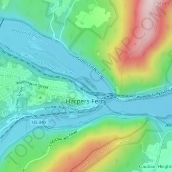
Naam: Topografische kaart Harpers Ferry, hoogte, reliëf.
Gemiddelde hoogte: 174 m
Minimale hoogte: 71 m
Maximale hoogte: 421 m
The town was "easy to seize, and hard to hold", because of its topography: surrounded on three sides by high ground – Bolivar Heights to the west, Loudoun Heights to the south, and Maryland Heights to the east – and surrounded by the Potomac and Shenandoah Rivers, anyone who controlled the heights controlled the city.
Andere topografische kaarten
Klik op een kaart om zijn topografie, zijn hoogte en zijn reliëf te bekijken.
Shepherdstown
United States > West Virginia > Jefferson County
Shepherdstown, Jefferson County, West Virginia, 25443, United States
Gemiddelde hoogte: 126 m
Kearneysville
United States > West Virginia > Jefferson County > Kearneysville
Kearneysville, Jefferson County, West Virginia, 25430-9047, United States
Gemiddelde hoogte: 162 m
Harpers Ferry National Historical Park
United States > West Virginia > Jefferson County > Bolivar
Harpers Ferry National Historical Park, Bolivar, Jefferson County, West Virginia, United States
Gemiddelde hoogte: 161 m
Charles Town
United States > West Virginia > Jefferson County
Charles Town, Jefferson County, West Virginia, United States
Gemiddelde hoogte: 150 m
Halltown
United States > West Virginia > Jefferson County > Halltown
Halltown, Jefferson County, West Virginia, 25423, United States
Gemiddelde hoogte: 133 m
Ranson
United States > West Virginia > Jefferson County
Ranson, Jefferson County, West Virginia, 25438, United States
Gemiddelde hoogte: 161 m