
Topografische kaart Henry M. Jackson Wilderness
Interactieve kaart
Klik op de kaart om de hoogte weer te geven.
Over deze kaart
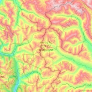
Naam: Topografische kaart Henry M. Jackson Wilderness, hoogte, reliëf.
Gemiddelde hoogte: 1.307 m
Minimale hoogte: 346 m
Maximale hoogte: 2.569 m
Andere topografische kaarten
Klik op een kaart om zijn topografie, zijn hoogte en zijn reliëf te bekijken.
Carrie Glacier
Carrie Glacier, Mount Carrie Way Trail, Clallam County, Washington, USA
Gemiddelde hoogte: 1.725 m
Olympic Mountains
Olympic Mountains, Jefferson County, Washington, 98305, USA
Gemiddelde hoogte: 511 m
Adams Glacier
Adams Glacier, High Camp Trail, Skamania County, Washington, USA
Gemiddelde hoogte: 2.634 m
Sulphide Glacier
Sulphide Glacier, Sulfide Glacier Route, Whatcom County, Washington, USA
Gemiddelde hoogte: 1.815 m
Mary Green Glacier
USA > Washington > Holden Village
Mary Green Glacier, Cloudy Pass Trail #1256, Holden Village, Chelan County, Washington, USA
Gemiddelde hoogte: 2.140 m
Sitkum Glacier
Sitkum Glacier, Pacific Crest Trail, Snohomish County, Washington, USA
Gemiddelde hoogte: 2.551 m
Richardson Glacier
Richardson Glacier, Chelan County, Washington, USA
Gemiddelde hoogte: 2.109 m
Terror Glacier
Terror Glacier, Whatcom County, Washington, USA
Gemiddelde hoogte: 1.866 m
Yawning Glacier
Yawning Glacier, Ptarmigan Traverse, Chelan County, Washington, USA
Gemiddelde hoogte: 1.712 m
Mount Rainier
Mount Rainier, Pierce County, Washington, USA
Gemiddelde hoogte: 3.938 m
Deming Glacier
Deming Glacier, Easton Glacier Route, Whatcom County, Washington, USA
Gemiddelde hoogte: 2.225 m
Kennedy Glacier
Kennedy Glacier, Pacific Crest Trail, Snohomish County, Washington, USA
Gemiddelde hoogte: 2.538 m
Fremont Glacier
Fremont Glacier, Thunder Creek Trail, Skagit County, Washington, USA
Gemiddelde hoogte: 2.216 m
Table Mountain Glacier
Table Mountain Glacier, Table Mountain Trail, Whatcom County, Washington, USA
Gemiddelde hoogte: 1.493 m
East Nooksack Glacier
East Nooksack Glacier, Nooksack Cirque Trail, Whatcom County, Washington, USA
Gemiddelde hoogte: 1.701 m
So-Bahli-Alhi Glacier
USA > Washington > White Horse
So-Bahli-Alhi Glacier, Neiderprum Trail, White Horse, Snohomish County, Washington, USA
Gemiddelde hoogte: 1.382 m
Stuart Glacier
Stuart Glacier, Horseshoe Lake Trail, Chelan County, Washington, USA
Gemiddelde hoogte: 2.098 m
Hubert Glacier
Hubert Glacier, Blue Glacier Primitive Trail, Jefferson County, Washington, USA
Gemiddelde hoogte: 1.802 m
Suiattle Glacier
Suiattle Glacier, Foam Creek Trail, Chelan County, Washington, USA
Gemiddelde hoogte: 2.153 m
Humes Glacier
Humes Glacier, Humes Glacier Route, Jefferson County, Washington, USA
Gemiddelde hoogte: 1.613 m
South Cascade Glacier
South Cascade Glacier, Ptarmigan Traverse, Chelan County, Washington, USA
Gemiddelde hoogte: 1.972 m
Chocolate Glacier
Chocolate Glacier, Pacific Crest Trail, Snohomish County, Washington, USA
Gemiddelde hoogte: 2.469 m
Katsuk Glacier
Katsuk Glacier, Fisher Creek Trail, Skagit County, Washington, USA
Gemiddelde hoogte: 2.007 m
Spire Glacier
Spire Glacier, Ptarmigan Traverse, Chelan County, Washington, USA
Gemiddelde hoogte: 1.946 m
Snow Creek Glacier
Snow Creek Glacier, Little Annapurna summit trail, Chelan County, Washington, USA
Gemiddelde hoogte: 2.225 m
Butterfly Glacier
Butterfly Glacier, Chelan County, Washington, USA
Gemiddelde hoogte: 2.121 m
Dana Glacier
Dana Glacier, Ptarmigan Traverse, Chelan County, Washington, USA
Gemiddelde hoogte: 2.003 m
Liberty Cap Glacier
Liberty Cap Glacier, Emmons Glacier Route, Pierce County, Washington, USA
Gemiddelde hoogte: 3.465 m
Tahoma Glacier
Tahoma Glacier, Wonderland Trail, Pierce County, Washington, USA
Gemiddelde hoogte: 2.517 m
Davenport Glacier
Davenport Glacier, Sahale Arm Trail, Skagit County, Washington, USA
Gemiddelde hoogte: 2.143 m
Easton Glacier
Easton Glacier, Easton Glacier Route, Whatcom County, Washington, USA
Gemiddelde hoogte: 2.193 m
Van Trump Glacier
USA > Washington > Paradise
Van Trump Glacier, Van Trump Trail, Paradise, Pierce County, Washington, USA
Gemiddelde hoogte: 2.389 m
White Glacier
White Glacier, Jefferson County, Washington, USA
Gemiddelde hoogte: 1.739 m
Rusk Glacier
Rusk Glacier, South Climb Trail #183, Yakima County, Washington, USA
Gemiddelde hoogte: 2.441 m
Shoestring Glacier
Shoestring Glacier, Worm Flows Climbing Route, Skamania County, Washington, USA
Gemiddelde hoogte: 1.945 m
Neve Glacier
USA > Washington > Diablo
Neve Glacier, Pyramid Lake Trail, Diablo, Whatcom County, Washington, USA
Gemiddelde hoogte: 2.074 m
White Salmon Glacier
White Salmon Glacier, Fisher Chimneys, Whatcom County, Washington, USA
Gemiddelde hoogte: 1.691 m
Ingraham Glacier
USA > Washington > Paradise
Ingraham Glacier, Camp Muir Route, Paradise, Pierce County, Washington, USA
Gemiddelde hoogte: 2.489 m
Roosevelt Glacier
Roosevelt Glacier, North Ridge Route, Whatcom County, Washington, USA
Gemiddelde hoogte: 2.394 m
Ice River Glacier
Ice River Glacier, Blue Glacier Primitive Trail, Jefferson County, Washington, USA
Gemiddelde hoogte: 1.640 m
Mazama Glacier
Mazama Glacier, South Climb Trail #183, Yakima County, Washington, USA
Gemiddelde hoogte: 2.568 m
Crater Glacier
Crater Glacier, Monitor Ridge Climbing Route, Skamania County, Washington, USA
Gemiddelde hoogte: 2.032 m
Borealis Glacier
Borealis Glacier, Lucky ridge boot trail, Skagit County, Washington, USA
Gemiddelde hoogte: 1.851 m
Wyeth Glacier
Wyeth Glacier, Park Creek Trail, Skagit County, Washington, USA
Gemiddelde hoogte: 1.994 m
Entiat Glacier
Entiat Glacier, Mount Maude Summit Approach, Chelan County, Washington, USA
Gemiddelde hoogte: 2.145 m
Pinnacle Glacier
Pinnacle Glacier, Pacific Crest Trail, Skamania County, Washington, USA
Gemiddelde hoogte: 2.253 m
Sandalee Glacier
Sandalee Glacier, McGregor Trail, Chelan County, Washington, USA
Gemiddelde hoogte: 1.910 m