
Topografische kaart Morton
Interactieve kaart
Klik op de kaart om de hoogte weer te geven.
Over deze kaart
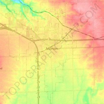
Naam: Topografische kaart Morton, hoogte, reliëf.
Locatie: Morton, Tazewell County, Illinois, 61550, United States (40.55614 -89.51667 40.66225 -89.42163)
Gemiddelde hoogte: 219 m
Minimale hoogte: 163 m
Maximale hoogte: 260 m
Andere topografische kaarten
Klik op een kaart om zijn topografie, zijn hoogte en zijn reliëf te bekijken.
Washington
United States > Illinois > Tazewell County
Washington, Tazewell County, Illinois, 61571, United States
Gemiddelde hoogte: 236 m
Deer Creek
United States > Illinois > Tazewell County
Deer Creek, Tazewell County, Illinois, United States
Gemiddelde hoogte: 227 m
Green Valley
United States > Illinois > Tazewell County
Green Valley, Tazewell County, Illinois, United States
Gemiddelde hoogte: 164 m
East Peoria
United States > Illinois > Tazewell County
East Peoria, Tazewell County, Illinois, 61611, United States
Gemiddelde hoogte: 176 m
Tazewell County
United States > Illinois > Tazewell County
Tazewell County, Illinois, United States
Gemiddelde hoogte: 190 m