
Topografische kaart Rajkot
Interactieve kaart
Klik op de kaart om de hoogte weer te geven.
Over deze kaart
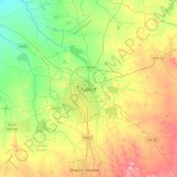
Naam: Topografische kaart Rajkot, hoogte, reliëf.
Locatie: Rajkot, Rajkot Taluka, Rajkot District, Gujarat, 360001, India (22.14533 70.64284 22.46533 70.96284)
Gemiddelde hoogte: 141 m
Minimale hoogte: 65 m
Maximale hoogte: 257 m
Rajkot is located at 22°18′N 70°47′E / 22.3°N 70.78°E / 22.3; 70.78. It has an average elevation of 128 metres (420 ft). The city is located on the bank of Aji River and Nyari River which remains dry except the monsoon months of July to September. The city is spread in the area of 170.00 km2.