
Topografische kaart Fort Smith
Interactieve kaart
Klik op de kaart om de hoogte weer te geven.
Over deze kaart
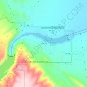
Naam: Topografische kaart Fort Smith, hoogte, reliëf.
Locatie: Fort Smith, Big Horn County, Montana, 59035, United States (45.29274 -107.95706 45.33274 -107.91706)
Gemiddelde hoogte: 1.059 m
Minimale hoogte: 963 m
Maximale hoogte: 1.322 m
Andere topografische kaarten
Klik op een kaart om zijn topografie, zijn hoogte en zijn reliëf te bekijken.
Lodge Grass
United States > Montana > Big Horn County > Lodge Grass
Lodge Grass, Big Horn County, Montana, 59050, United States
Gemiddelde hoogte: 1.077 m
Busby
United States > Montana > Big Horn County > Busby
Busby, Busby District, Big Horn County, Montana, 59016, United States
Gemiddelde hoogte: 1.090 m
Black Canyon
United States > Montana > Big Horn County
Black Canyon, Big Horn County, Montana, United States
Gemiddelde hoogte: 1.357 m