
Topografische kaart Morris Island
Interactieve kaart
Klik op de kaart om de hoogte weer te geven.
Over deze kaart
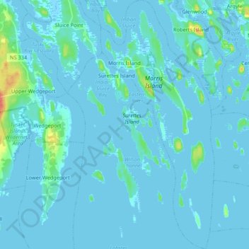
Naam: Topografische kaart Morris Island, hoogte, reliëf.
Gemiddelde hoogte: 3 m
Minimale hoogte: -4 m
Maximale hoogte: 48 m
Andere topografische kaarten
Klik op een kaart om zijn topografie, zijn hoogte en zijn reliëf te bekijken.
Sluice Point
Canada > Nova Scotia > Yarmouth County
Sluice Point, Argyle Municipal District, Yarmouth County, Nova Scotia, B5A 5P7, Canada
Gemiddelde hoogte: 120 m
Indian Bay
Canada > Nova Scotia > Yarmouth County > Abrams River
Indian Bay, Abrams River, Argyle Municipal District, Yarmouth County, Nova Scotia, B0W 3M0, Canada
Gemiddelde hoogte: 4 m
Calf Island
Canada > Nova Scotia > Yarmouth County > East Pubnico
Calf Island, East Pubnico, Argyle Municipal District, Yarmouth County, Nova Scotia, B0W 2W0, Canada
Gemiddelde hoogte: 20 m
Big Gooseberry Island
Canada > Nova Scotia > Yarmouth County > Argyle Sound
Big Gooseberry Island, Argyle Sound, Argyle Municipal District, Yarmouth County, Nova Scotia, Canada
Gemiddelde hoogte: 0 m