
Topografische kaart Town of Kelly
Interactieve kaart
Klik op de kaart om de hoogte weer te geven.
Over deze kaart
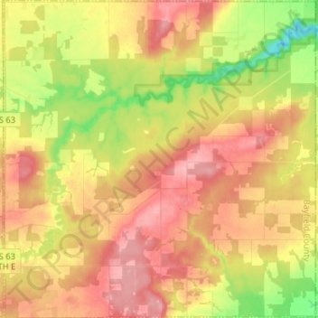
Naam: Topografische kaart Town of Kelly, hoogte, reliëf.
Locatie: Town of Kelly, Bayfield County, Wisconsin, United States (46.41359 -91.05098 46.50225 -90.92442)
Gemiddelde hoogte: 281 m
Minimale hoogte: 221 m
Maximale hoogte: 325 m
Andere topografische kaarten
Klik op een kaart om zijn topografie, zijn hoogte en zijn reliëf te bekijken.
Raspberry Island
United States > Wisconsin > Bayfield County
Raspberry Island, Town of Russell, Bayfield County, Wisconsin, United States
Gemiddelde hoogte: 182 m
Houghton Point
United States > Wisconsin > Bayfield County
Houghton Point, Town of Bayview, Bayfield County, Wisconsin, United States
Gemiddelde hoogte: 192 m
Town of Namakagon
United States > Wisconsin > Bayfield County
Town of Namakagon, Bayfield County, Wisconsin, United States
Gemiddelde hoogte: 443 m
Sand Bay
United States > Wisconsin > Bayfield County > Sand Bay
Sand Bay, Town of Russell, Bayfield County, Wisconsin, United States
Gemiddelde hoogte: 209 m