
Topografische kaart La Tannerie
Interactieve kaart
Klik op de kaart om de hoogte weer te geven.
Over deze kaart
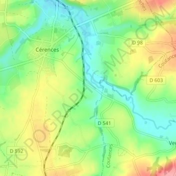
Naam: Topografische kaart La Tannerie, hoogte, reliëf.
Gemiddelde hoogte: 52 m
Minimale hoogte: 16 m
Maximale hoogte: 108 m
Andere topografische kaarten
Klik op een kaart om zijn topografie, zijn hoogte en zijn reliëf te bekijken.
L'Hôtel au Roy
France > Normandie > Manche > Cérences
L'Hôtel au Roy, Cérences, Avranches, Manche, Normandie, France métropolitaine, 50510, France
Gemiddelde hoogte: 51 m
Les Carrières
France > Normandie > Manche > Cérences
Les Carrières, Cérences, Avranches, Manche, Normandie, France métropolitaine, 50510, France
Gemiddelde hoogte: 49 m
L'Hôtel Boschet
France > Normandie > Manche > Cérences
L'Hôtel Boschet, Cérences, Avranches, Manche, Normandie, France métropolitaine, 50510, France
Gemiddelde hoogte: 49 m
Hameau Girot
France > Normandie > Manche > Cérences
Hameau Girot, Cérences, Avranches, Manche, Normandie, France métropolitaine, 50510, France
Gemiddelde hoogte: 55 m