
Topografische kaart Vienna
Interactieve kaart
Klik op de kaart om de hoogte weer te geven.
Vienna
Vienna is located at 38°54′N 77°16′W / 38.900°N 77.267°W / 38.900; -77.267 (38.8991, −77.2607), at an elevation of 358 feet (109 meters). It lies in the Piedmont approximately 5.5 miles (8.9 km) southwest of the Potomac River. Wolftrap Creek, a tributary of nearby Difficult Run, flows north from its source in the eastern part of town. The Bear Branch of Accotink Creek, a Potomac tributary, flows south from its source in the southern part of town. Located in Northern Virginia on Interstate 66, Vienna is 12 miles (19 km) west of Washington, D.C. and 2 miles (3.2 km) northeast of Fairfax, the county seat.
Over deze kaart
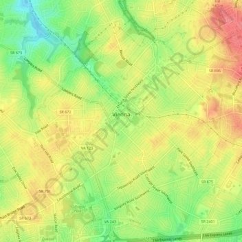
Naam: Topografische kaart Vienna, hoogte, reliëf.
Locatie: Vienna, Fairfax County, Virginia, United States (38.87854 -77.28476 38.92182 -77.24109)
Gemiddelde hoogte: 117 m
Minimale hoogte: 76 m
Maximale hoogte: 151 m
Andere topografische kaarten
Klik op een kaart om zijn topografie, zijn hoogte en zijn reliëf te bekijken.
Izaak Walton League of America - Arlington-Fairfax Chapter
United States > Virginia > Fairfax County > Centreville
Gemiddelde hoogte: 72 m
George Washington's Mount Vernon
United States > Virginia > Fairfax County > Mount Vernon
Visitors to Mount Vernon now see Washington's study, a room to which in the 18th century only a privileged few were granted entry. This simply furnished room has a combined bathroom, dressing room and office; the room was so private that few contemporary descriptions exist. Its walls are lined with naturally…
Gemiddelde hoogte: 14 m
Mount Vernon Community Park
United States > Virginia > Fairfax County > Fort Hunt > Snowden
Gemiddelde hoogte: 14 m
Shirley Gate Park
United States > Virginia > Fairfax County > George Mason > Shirley Gate Park
Gemiddelde hoogte: 128 m