
Topografische kaart Hot Springs
Interactieve kaart
Klik op de kaart om de hoogte weer te geven.
Over deze kaart
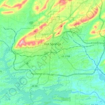
Naam: Topografische kaart Hot Springs, hoogte, reliëf.
Locatie: Hot Springs, Garland County, Arkansas, United States (34.42644 -93.12905 34.55940 -92.98510)
Gemiddelde hoogte: 172 m
Minimale hoogte: 92 m
Maximale hoogte: 420 m
Andere topografische kaarten
Klik op een kaart om zijn topografie, zijn hoogte en zijn reliëf te bekijken.
Bear
United States > Arkansas > Garland County
Bear, Garland County, Arkansas, 71968, United States
Gemiddelde hoogte: 216 m
Lake Ouachita
United States > Arkansas > Garland County
Lake Ouachita, Garland County, Arkansas, United States
Gemiddelde hoogte: 241 m
Hot Springs Village
United States > Arkansas > Garland County > Hot Springs Village
Hot Springs Village, Garland County, Arkansas, 71909, United States
Gemiddelde hoogte: 226 m
Garland County
United States > Arkansas > Garland County
Garland County, Arkansas, United States
Gemiddelde hoogte: 224 m