
Doe een donatie
Rust jezelf uit voor je volgende avontuur:
Als Amazon-partner verdient deze site een commissie op in aanmerking komende aankopen, zonder extra kosten voor jou.
Topografische kaart Atlanta
Klik op de kaart om de hoogte weer te geven.
Doe een donatie
Rust jezelf uit voor je volgende avontuur:
Als Amazon-partner verdient deze site een commissie op in aanmerking komende aankopen, zonder extra kosten voor jou.
Atlanta
Atlanta occupies a high, rolling part of the Georgia Piedmont, a physiographic region described as a landscape of low hills and narrow valleys between the Blue Ridge Mountains and the Upper Coastal Plain. Around downtown and Fulton County, the terrain is gently dissected rather than flat, with broad urban ridges, shallow creek valleys, and a generally elevated plateau-like character; the city is commonly described as lying just over 1,000 feet (about 300 meters) above sea level, while lower ground appears along drainage corridors such as Peachtree Creek, Proctor Creek, Utoy Creek, and the Chattahoochee River system. The local relief is moderate but persistent, producing a landscape of undulating neighborhoods, wooded slopes, and stream-cut troughs rather than dramatic mountains, while isolated higher features such as Stone Mountain to the east emphasize the Piedmont’s pattern of rounded uplands and occasional resistant rock masses. The overall physical character is therefore that of an elevated, humid, forested urban Piedmont terrain: a city built across ridgelines and rolling hills, with elevation gradually stepping down toward its creeks and river valleys.
Doe een donatie
Rust jezelf uit voor je volgende avontuur:
Als Amazon-partner verdient deze site een commissie op in aanmerking komende aankopen, zonder extra kosten voor jou.
Over deze kaart
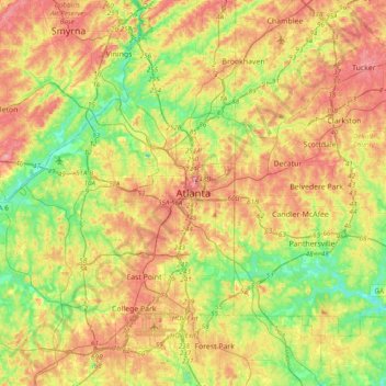
Naam: Topografische kaart Atlanta, hoogte, reliëf.
Locatie: Atlanta, Fulton County, Georgia, 30303, United States (33.58899 -84.55026 33.90899 -84.23026)
Gemiddelde hoogte: 285 m
Minimale hoogte: 221 m
Maximale hoogte: 359 m
Doe een donatie
Rust jezelf uit voor je volgende avontuur:
Als Amazon-partner verdient deze site een commissie op in aanmerking komende aankopen, zonder extra kosten voor jou.
Andere topografische kaarten
Klik op een kaart om zijn topografie, zijn hoogte en zijn reliëf te bekijken.
Doe een donatie
Rust jezelf uit voor je volgende avontuur:
Als Amazon-partner verdient deze site een commissie op in aanmerking komende aankopen, zonder extra kosten voor jou.