
Topografische kaart Santo Tomas
Interactieve kaart
Klik op de kaart om de hoogte weer te geven.
Over deze kaart
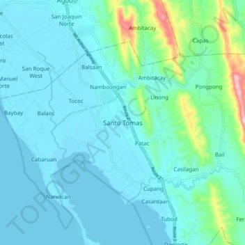
Naam: Topografische kaart Santo Tomas, hoogte, reliëf.
Locatie: Santo Tomas, La Union, Ilocos Region, 2505, Philippines (16.24235 120.34672 16.32235 120.42672)
Gemiddelde hoogte: 40 m
Minimale hoogte: -1 m
Maximale hoogte: 281 m
Andere topografische kaarten
Klik op een kaart om zijn topografie, zijn hoogte en zijn reliëf te bekijken.
Sungyot Island
Philippines > La Union > Santo Tomas
Sungyot Island, Santo Tomas, La Union, Ilocos Region, Philippines
Gemiddelde hoogte: 0 m
Cupang
Philippines > La Union > Santo Tomas
Cupang, Santo Tomas, La Union, Ilocos Region, Philippines
Gemiddelde hoogte: 23 m
Tubod
Philippines > La Union > Santo Tomas
Tubod, Santo Tomas, La Union, Ilocos Region, Philippines
Gemiddelde hoogte: 24 m
Agoo-Damortis Protected Landscape and Seascape
Philippines > La Union > Santo Tomas
Agoo-Damortis Protected Landscape and Seascape, Santo Tomas, La Union, Ilocos Region, Philippines
Gemiddelde hoogte: 9 m
Damortis
Philippines > La Union > Santo Tomas
Damortis, Santo Tomas, La Union, Philippines
Gemiddelde hoogte: 25 m
Parasapas
Philippines > La Union > Santo Tomas
Parasapas, Santo Tomas, La Union, Ilocos Region, 2508, Philippines
Gemiddelde hoogte: 202 m