
Topografische kaart Clouds Creek
Interactieve kaart
Klik op de kaart om de hoogte weer te geven.
Over deze kaart
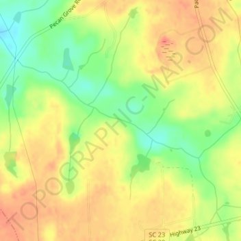
Naam: Topografische kaart Clouds Creek, hoogte, reliëf.
Gemiddelde hoogte: 182 m
Minimale hoogte: 153 m
Maximale hoogte: 201 m
Andere topografische kaarten
Klik op een kaart om zijn topografie, zijn hoogte en zijn reliëf te bekijken.
Bowman
United States of America > South Carolina > Bowman
Bowman, Orangeburg County, South Carolina, United States of America
Gemiddelde hoogte: 41 m
Nixons Crossroads
United States of America > South Carolina > Nixons Crossroads
Nixons Crossroads, Horry County, South Carolina, 29566, United States of America
Gemiddelde hoogte: 5 m
Avondale Heights
United States of America > South Carolina > Easley > Avondale Heights
Avondale Heights, Easley, Pickens County, South Carolina, 29640, United States of America
Gemiddelde hoogte: 309 m
Youngs
United States of America > South Carolina > Youngs
Youngs, Laurens County, South Carolina, United States of America
Gemiddelde hoogte: 213 m
Spring Gully
United States of America > South Carolina
Spring Gully, Georgetown County, South Carolina, United States of America
Gemiddelde hoogte: 4 m
The Groves
United States of America > South Carolina > The Groves
The Groves, Charleston County, South Carolina, 29464, United States of America
Gemiddelde hoogte: 4 m
Quarantine
United States of America > South Carolina > Quarantine
Quarantine, Georgetown County, South Carolina, United States of America
Gemiddelde hoogte: 0 m
Weddell
United States of America > South Carolina > Weddell
Weddell, Dentsville, Richland County, South Carolina, 29223, United States of America
Gemiddelde hoogte: 88 m
Dawkins
United States of America > South Carolina > Dawkins
Dawkins, Fairfield County, South Carolina, United States of America
Gemiddelde hoogte: 104 m
Travelers Rest
United States of America > South Carolina > Travelers Rest > Travelers Rest
Travelers Rest, Greenville County, South Carolina, United States of America
Gemiddelde hoogte: 338 m