
Topografische kaart Murphy
Interactieve kaart
Klik op de kaart om de hoogte weer te geven.
Over deze kaart
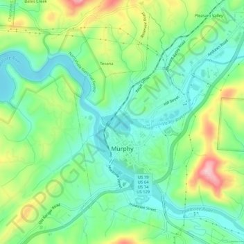
Naam: Topografische kaart Murphy, hoogte, reliëf.
Locatie: Murphy, Cherokee County, North Carolina, United States (35.07100 -84.04487 35.11326 -84.00244)
Gemiddelde hoogte: 514 m
Minimale hoogte: 448 m
Maximale hoogte: 648 m
Murphy has a humid subtropical climate, (Cfa) according to the Köppen classification, with hot, humid summers and cool to mild winters, with low temperatures significantly cooler than other parts of the Southeast, due in part to the elevation. Like the rest of the southeastern U.S., Murphy receives abundant rainfall, greatest in winter and enhanced by the elevation. Receiving as much as 100 inches per year in some parts, areas of Cherokee County are considered part of the Appalachian temperate rainforest. Blizzards are rare but possible; the 1993 Storm of the Century dropped 15 inches (38 cm) in 24 hours with more snowfall continuing up to 38" in some areas, causing widespread power outages and natural disasters.
Andere topografische kaarten
Klik op een kaart om zijn topografie, zijn hoogte en zijn reliëf te bekijken.
Andrews
United States > North Carolina > Cherokee County
Andrews, Cherokee County, North Carolina, 28901, United States
Gemiddelde hoogte: 593 m
Pleasant Valley
United States > North Carolina > Cherokee County
Pleasant Valley, Cherokee County, North Carolina, United States
Gemiddelde hoogte: 550 m
Peachtree
United States > North Carolina > Cherokee County
Peachtree, Cherokee County, North Carolina, United States
Gemiddelde hoogte: 535 m
Ebenezer
United States > North Carolina > Cherokee County
Ebenezer, Cherokee County, North Carolina, United States
Gemiddelde hoogte: 572 m
Pleasant Hill
United States > North Carolina > Cherokee County > Pleasant Hill
Pleasant Hill, Cherokee County, North Carolina, United States
Gemiddelde hoogte: 464 m
Murphy
United States > North Carolina > Cherokee County > Murphy
Murphy, Cherokee County, North Carolina, United States
Gemiddelde hoogte: 528 m
Topton
United States > North Carolina > Cherokee County > Topton
Topton, Cherokee County, North Carolina, United States
Gemiddelde hoogte: 980 m
Persimmon Creek
United States > North Carolina > Cherokee County
Persimmon Creek, Cherokee County, North Carolina, United States
Gemiddelde hoogte: 490 m
Marble
United States > North Carolina > Cherokee County
Marble, Cherokee County, North Carolina, 28905, United States
Gemiddelde hoogte: 571 m