
Topografische kaart Millstream
Interactieve kaart
Klik op de kaart om de hoogte weer te geven.
Over deze kaart
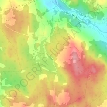
Naam: Topografische kaart Millstream, hoogte, reliëf.
Gemiddelde hoogte: 114 m
Minimale hoogte: 45 m
Maximale hoogte: 170 m
Andere topografische kaarten
Klik op een kaart om zijn topografie, zijn hoogte en zijn reliëf te bekijken.
Scotch Hill
Canada > Nouvelle-Écosse > Municipality of Pictou County
Scotch Hill, Municipality of Pictou County, Pictou County, Nouvelle-Écosse, Canada
Gemiddelde hoogte: 52 m