
Topografische kaart Kimberley
Interactieve kaart
Klik op de kaart om de hoogte weer te geven.
Over deze kaart
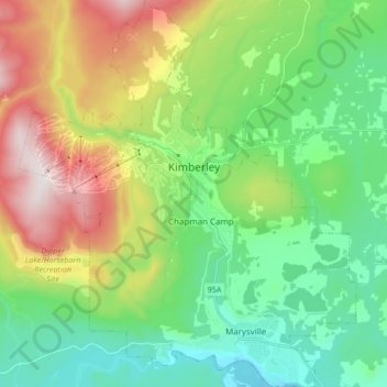
Naam: Topografische kaart Kimberley, hoogte, reliëf.
Gemiddelde hoogte: 1.216 m
Minimale hoogte: 879 m
Maximale hoogte: 1.905 m
Kimberley has a continental climate with semi-arid influences and heavy moderation from the nearby mountains which tend to block arctic air masses, and produce a rain shadow. Its fairly high elevation counters this effect slightly, as temperatures are somewhat cooler and the town slightly more rainy than it would otherwise be.
Andere topografische kaarten
Klik op een kaart om zijn topografie, zijn hoogte en zijn reliëf te bekijken.
Findlay Creek
Canada > British Columbia > Regional District of East Kootenay > Area F (Columbia Lake/Windermere Lake)
Findlay Creek, Area F (Columbia Lake/Windermere Lake), Regional District of East Kootenay, British Columbia, Canada
Gemiddelde hoogte: 1.862 m
White Man Pass
Canada > British Columbia > Regional District of East Kootenay > Area F (Columbia Lake/Windermere Lake)
White Man Pass, Area F (Columbia Lake/Windermere Lake), Regional District of East Kootenay, British Columbia, Canada
Gemiddelde hoogte: 2.199 m
Area C (Moyie/Bull River)
Canada > British Columbia > Regional District of East Kootenay
Area C (Moyie/Bull River), Regional District of East Kootenay, British Columbia, Canada
Gemiddelde hoogte: 1.572 m
Fernie
Canada > British Columbia > Regional District of East Kootenay
Fernie, Regional District of East Kootenay, British Columbia, Canada
Gemiddelde hoogte: 1.141 m
White Creek
Canada > British Columbia > Regional District of East Kootenay > Area E (Saint Mary/Skookumchuck)
White Creek, Area E (Saint Mary/Skookumchuck), Regional District of East Kootenay, British Columbia, Canada
Gemiddelde hoogte: 1.641 m
Area F (Columbia Lake/Windermere Lake)
Canada > British Columbia > Regional District of East Kootenay
Area F (Columbia Lake/Windermere Lake), Regional District of East Kootenay, British Columbia, Canada
Gemiddelde hoogte: 1.815 m
Fernie
Canada > British Columbia > Regional District of East Kootenay > Fernie
Fernie, Regional District of East Kootenay, British Columbia, V0B 1M0, Canada
Gemiddelde hoogte: 1.551 m
Hewitt Peak
Canada > British Columbia > Regional District of East Kootenay > Area G (Forster Creek/Mount Assiniboine)
Hewitt Peak, Area G (Forster Creek/Mount Assiniboine), Regional District of East Kootenay, British Columbia, Canada
Gemiddelde hoogte: 2.434 m
Radium Hot Springs
Canada > British Columbia > Regional District of East Kootenay > Radium Hot Springs
Radium Hot Springs, Regional District of East Kootenay, British Columbia, V0A 1M0, Canada
Gemiddelde hoogte: 913 m
Area G (Forster Creek/Mount Assiniboine)
Canada > British Columbia > Regional District of East Kootenay
Area G (Forster Creek/Mount Assiniboine), Regional District of East Kootenay, British Columbia, Canada
Gemiddelde hoogte: 1.808 m
Elkford
Canada > British Columbia > Regional District of East Kootenay > Elkford
Elkford, Regional District of East Kootenay, British Columbia, Canada
Gemiddelde hoogte: 1.895 m
Shuswap
Canada > British Columbia > Regional District of East Kootenay > Area F (Columbia Lake/Windermere Lake) > Shuswap
Shuswap, Area F (Columbia Lake/Windermere Lake), Regional District of East Kootenay, British Columbia, V0A 1K3, Canada
Gemiddelde hoogte: 926 m