
Topografische kaart Dublin Castle
Interactieve kaart
Klik op de kaart om de hoogte weer te geven.
Over deze kaart
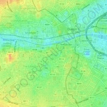
Naam: Topografische kaart Dublin Castle, hoogte, reliëf.
Gemiddelde hoogte: 16 m
Minimale hoogte: 1 m
Maximale hoogte: 32 m
The Poddle was diverted into the city through archways where the walls adjoined the castle, artificially flooding the moat of the fortress's city elevations. One of these archways and part of the wall survive buried underneath the 18th-century buildings, and are open for public viewing.
Andere topografische kaarten
Klik op een kaart om zijn topografie, zijn hoogte en zijn reliëf te bekijken.
Priorswood
Ireland > County Dublin > Dublin
Priorswood, Priorswood E Ward 1986, Dublin, County Dublin, Leinster, D17 XV48, Ireland
Gemiddelde hoogte: 42 m
Liberty of Donore
Ireland > County Dublin > Dublin
Liberty of Donore, Kimmage C Ward 1986, Dublin, County Dublin, Leinster, Ireland
Gemiddelde hoogte: 27 m
Darndale
Ireland > County Dublin > Dublin
Darndale, Priorswood C Ward 1986, Dublin, County Dublin, Leinster, Ireland
Gemiddelde hoogte: 35 m
Bluebell
Ireland > County Dublin > Dublin
Bluebell, Inchicore B Ward 1986, Dublin, County Dublin, Leinster, Ireland
Gemiddelde hoogte: 44 m
Ballygall
Ireland > County Dublin > Dublin
Ballygall, Finglas East D ED, Dublin, County Dublin, Leinster, Ireland
Gemiddelde hoogte: 53 m
Dublin
Ireland > County Dublin > Dublin
Dublin, Dún Laoghaire-Rathdown, County Dublin, Leinster, Ireland
Gemiddelde hoogte: 23 m
Sandymount
Ireland > County Dublin > Dublin
Sandymount, Pembroke East C ED, Dublin, County Dublin, Leinster, Ireland
Gemiddelde hoogte: 5 m
Santry
Ireland > County Dublin > Dublin
Santry, Whitehall C ED, Dublin, County Dublin, Leinster, Ireland
Gemiddelde hoogte: 54 m
Glasnevin
Ireland > County Dublin > Dublin
Glasnevin, Glasnevin A ED, Dublin, County Dublin, Leinster, D09 YN97, Ireland
Gemiddelde hoogte: 33 m
North Bull Island
Ireland > County Dublin > Dublin
North Bull Island, Raheny St. Assam ED, Dublin, County Dublin, Leinster, Ireland
Gemiddelde hoogte: 2 m
Rathgar
Ireland > County Dublin > Dublin
Rathgar, Rathfarnham A ED, Dublin, County Dublin, Leinster, Ireland
Gemiddelde hoogte: 40 m
Santry
Ireland > County Dublin > Dublin
Santry, Dublin, Fingal, County Dublin, Leinster, Ireland
Gemiddelde hoogte: 49 m
Belcamp
Ireland > County Dublin > Dublin
Belcamp, Priorswood B ED, Dublin, County Dublin, Leinster, Ireland
Gemiddelde hoogte: 37 m
Clonmel
Ireland > County Dublin > Dublin
Clonmel, Ballymun E ED, Dublin, County Dublin, Leinster, Ireland
Gemiddelde hoogte: 57 m
Rathmines
Ireland > County Dublin > Dublin
Rathmines, Rathmines West B ED, Dublin, County Dublin, Leinster, Ireland
Gemiddelde hoogte: 28 m
Walkinstown
Ireland > County Dublin > Dublin
Walkinstown, Walkinstown B Ward 1986, Dublin, County Dublin, Leinster, Ireland
Gemiddelde hoogte: 49 m
Donnycarney
Ireland > County Dublin > Dublin
Donnycarney, Drumcondra North A ED, Dublin, County Dublin, Leinster, Ireland
Gemiddelde hoogte: 24 m
Terenure
Ireland > County Dublin > Dublin
Terenure, Rathfarnham A ED, Dublin, County Dublin, Leinster, D06 K767, Ireland
Gemiddelde hoogte: 45 m
Irishtown
Ireland > County Dublin > Dublin
Irishtown, Pembroke East A ED, Dublin, County Dublin, Leinster, Ireland
Gemiddelde hoogte: 5 m