
Topografische kaart Deggingen
Interactieve kaart
Klik op de kaart om de hoogte weer te geven.
Over deze kaart
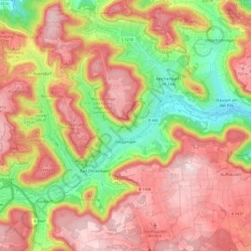
Naam: Topografische kaart Deggingen, hoogte, reliëf.
Gemiddelde hoogte: 643 m
Minimale hoogte: 456 m
Maximale hoogte: 787 m
The municipality (Gemeinde) of Deggingen is found in the district of Göppingen, in Baden-Württemberg, one of the 16 States of the Federal Republic of Germany. Deggingen is physically located in the upper Fils river valley, in the Filsalb region of the Middle Kuppenalb . Elevation above sea level in the municipal area ranges from a high of 777 meters (2,549 ft) Normalnull (NN) to a low of 465 meters (1,526 ft) NN.