
Topografische kaart Fort Wayne
Interactieve kaart
Klik op de kaart om de hoogte weer te geven.
Over deze kaart
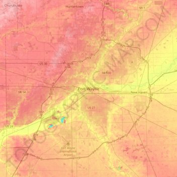
Naam: Topografische kaart Fort Wayne, hoogte, reliëf.
Locatie: Fort Wayne, Allen County, Indiana, 46802, United States (40.91999 -85.29860 41.23999 -84.97860)
Gemiddelde hoogte: 248 m
Minimale hoogte: 185 m
Maximale hoogte: 280 m
The first settlement started in 1815. In 1819, the military garrison abandoned the fort and moved to Detroit. In 1822, a federal land office opened to sell land ceded by local Native Americans by the Treaty of St. Mary's in 1818. Platted in 1823 at the Ewing Tavern, the village became an important frontier outpost, and was incorporated as the Town of Fort Wayne in 1829, with a population of 300. The Wabash and Erie Canal's opening improved travel conditions to the Great Lakes and Mississippi River, exposing Fort Wayne to expanded economic opportunities. The population topped 2,000 when the town was incorporated as the City of Fort Wayne on February 22, 1840. Pioneer newspaperman George W. Wood was elected the city's first mayor. Fort Wayne's "Summit City" nickname dates from this period, referring to the city's position at the highest elevation along the canal's route. As influential as the canal was to the city's earliest development, it quickly became obsolete after briefly competing with the city's first railroad, the Pittsburgh, Fort Wayne and Chicago Railway, completed in 1854.
Andere topografische kaarten
Klik op een kaart om zijn topografie, zijn hoogte en zijn reliëf te bekijken.
Rain Pond
United States > Indiana > Allen County > Fort Wayne
Rain Pond, Fall Creek, Fort Wayne, Allen County, Indiana, United States
Gemiddelde hoogte: 247 m