
Topografische kaart Barasat
Interactieve kaart
Klik op de kaart om de hoogte weer te geven.
Over deze kaart
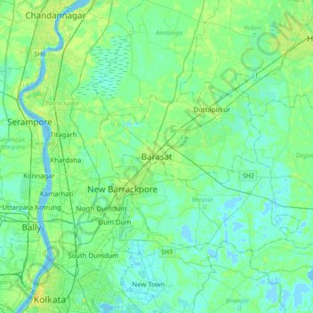
Naam: Topografische kaart Barasat, hoogte, reliëf.
Gemiddelde hoogte: 6 m
Minimale hoogte: -3 m
Maximale hoogte: 22 m
Its average elevation is 11 metres (36 ft). The nearest river is the Ganges, about 15 kilometres (9.3 mi) to the west, and it is on the Gangetic plain.
Andere topografische kaarten
Klik op een kaart om zijn topografie, zijn hoogte en zijn reliëf te bekijken.
Gangapur
India > West Bengal > Barasat - I
Gangapur, Barasat - I, North 24 Parganas District, West Bengal, 743248, India
Gemiddelde hoogte: 7 m